Thursday, June 27, 2013

Cape Town to Saint Helena (2013)


After waiting close to a week for the winds in Cape Town to settle down, we headed out on January 31st.  Our next stop would be the island of Saint Helena, 1,700 miles to the northwest.  The strategy for this leg of the trip is to wait for a few days of light winds in Cape Town and make it as far north as possible before the next big blow comes.  In the case of Cape Town, light winds usually mean 20 – 30 knots. 

This passage is normally quite boisterous for the first few days, and our trip was no exception.  We had S to SE winds at 20-25 knots for the first four days, with a sizable SW swell, and Saviah carried us along at over 6 knots, knocking off 150 miles a day.  At this pace, we began to think we could reach Saint Helena in 11 days.

On our fifth day out, the winds lightened, which typically happens near the tropics.  We did everything we could to maintain our speed, but our average daily run over the next six days dropped to a disappointing 109 miles.  We sailed with our big spinnaker for two days, until one night a very mild squall with gusts up to 15 knots swept through.  This sail was already near the end of its life, and a little bit more pressure from a gust caused the sail to rip all the way across, about four feet from the head.   No longer held on top, the sail went forward and into the water. 

This happened around 2 am, when Di was on watch, and she ran forward and pulled in all 500+ square feet of sail and piled it on deck.  It was good that she got it out of the water quickly before we ran over it, which could have created a tangled mess under the keel. By the time Andrew woke up and ran up top, the whole thing was pretty much over.  

We discussed switching out to the smaller gennaker, but the halyard was stuck at the top of the mast, along with the head of the spinnaker.  So we did our best with the poled out genoa, although this is our favorite sail and hearing it luff for days on end is very frustrating.  By day 11, we had almost no wind at all and averaged only 60 miles for the following three days.  It seemed that the current was likely responsible for at least half of those miles.

During these periods of very light winds, we tried to be patient and wait it out rather than motor.  We were uncertain of refueling options in Saint Helena and decided to save our diesel for crossing the ITCZ (doldrums) on the next passage.  This made for some very long days, but at least the seas were flat. 

On day 14, the SE trade winds filled in at 10-12 knots, and Saviah was finally moving along a bit faster.  We approached Saint Helena at night after 16 days at sea on what ended up being one of our slowest passages, averaging only 106 miles per day.  We opted to heave-to for the night and sailed around to the leeward side of the island the next morning after sunrise. 

Saint Helena is an island of volcanic origin, measuring approximately five miles by ten miles.   It was originally claimed by the Portuguese and then later by both the Dutch and English and was an important stopover for ships going from Europe to Asia before the opening of the Suez Canal.  The English were the first to fortify and colonize the island, and it remains one of the oldest British colonies and one of the most isolated islands in the world.  There are currently about 4,300 residents living here, mostly descendants of the original English settlers, soldiers and their slaves.  

James Bay, Saint Helena
Approaching the city of Jamestown, we were a bit nervous as the information we had showed the primary anchorage in 90 feet of water with a very steeply sloping sea floor.  In order to anchor in water that deep, we would need to put out all 250 ft of our chain, at about a pound per foot, in addition to our oversized 55 lb anchor. Our windlass is still broken and the thought of pulling up all of that weight by hand when it was time to go was daunting.  We also read that because of the steep ocean floor many boats have problems dragging off to sea. 

As we neared the anchorage, we were pleasantly surprised to see seven other cruising boats there, and all were tied up to moorings with another 15 available nearby.  We called the port on the VHF and got permission to tie up to one.  Apparently they were installed just a few months prior, which was a big relief. 

After Saviah was moored, one of the small ferry boats stopped by, and the driver said he would pick us up in an hour.  There is a wharf on the other side of the bay with a concrete wall where it is possible to land a dinghy.  Even when the winds are light and the ocean swell is minimal, there still seems to be a sizeable swell that rolls into the wharf, making a dinghy landing very wet and often dangerous. 

Fortunately, the port provides a ferry service that runs cruisers and the local fisherman from their boats to the wharf and back again throughout the day.  This means you can arrive at shore dry and with your dinghy in one piece, although it still takes a bit of coordination to get on and off of the small ferry boat as it rises and falls in the swell.  Near the wall, several lengths of knotted rope hang down for you to grab and swing onto the concrete, while the boat drops from under you. 

Once ashore, our first priority was to clear in with the officials in Jamestown.  This is the primary town and capital of the island, sitting at the bottom of a long and narrow valley with steep, bare cliffs rising up on both sides.  We asked for directions to the immigration office and were told to cross over the moat that leads into town, and look for the police station across the street from the castle.  There were many old colonial buildings lining the narrow streets, and it was interesting to imagine all of the history that has taken place in this remote island since it was settled 350 years ago. 

Jamestown
Our next stop was the bank.  There aren’t any ATM’s on the island, so we needed to exchange our US dollars.  The island has its own currency, the Saint Helena pound, which is on par with the pound sterling.  We then stopped at the local grocery store to stock up on fresh produce.  The supply ship apparently hadn’t been in port in a while, and most of what we found looked a bit tired. The only produce we ended up buying were a few potatoes and onions.  They did have fresh bread, eggs and cheese, which we were happy to see. 

The next day, we took the ferry back into Jamestown, to explore the city and get a bit of exercise.  The first thing we did was to climb Jacob’s Ladder.  This is an inclined plane that was built in 1892 to haul manure up to the fort on Ladder Hill and to bring goods back down.  There are 699 steps to the top, and after sitting on the boat for the last 16 days, it was not easy. 
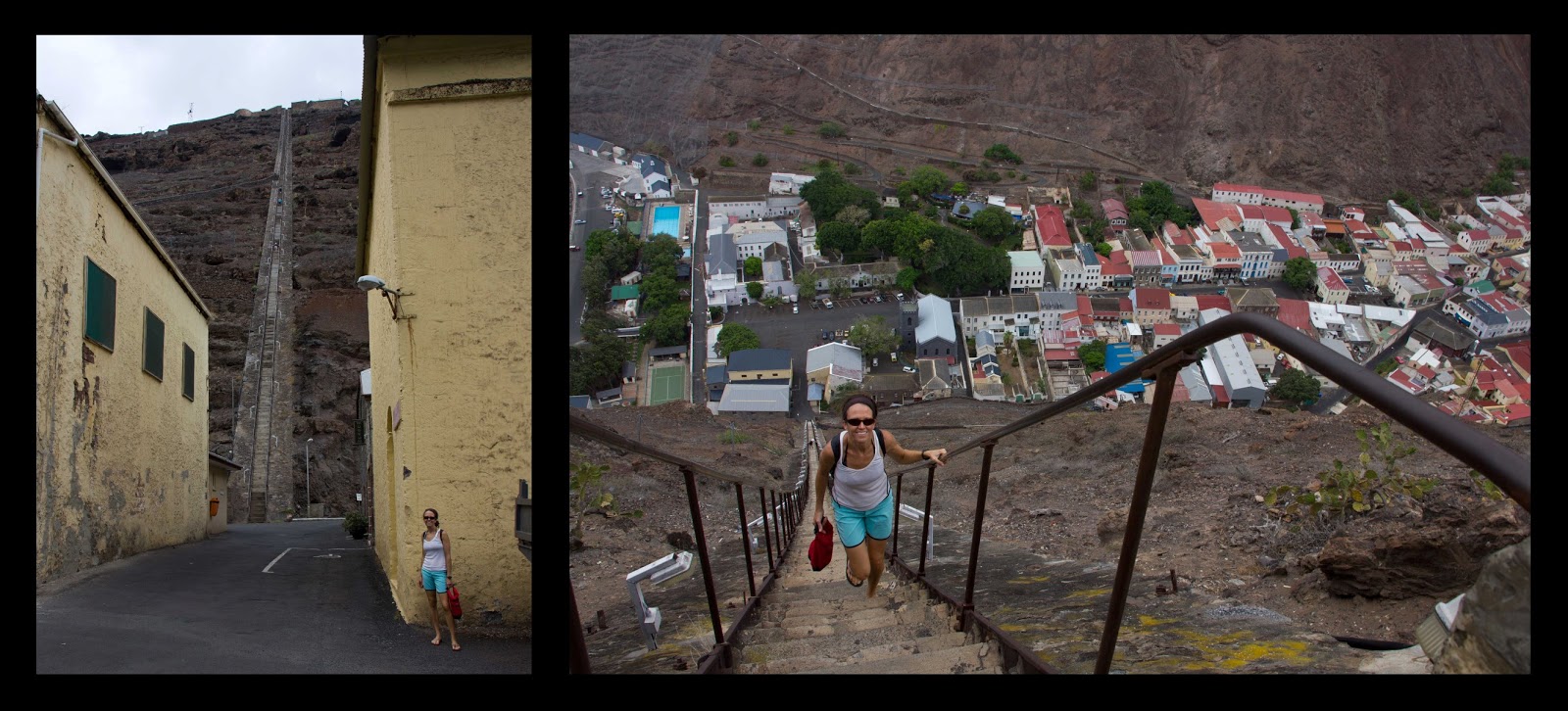
Jacob's Ladder
Since we needed to start the next leg of our Atlantic crossing in four of five days, we decided to do one of the local tours and see as much of the island as we could during our brief visit.  One of the local guides said he would show us around, and five other cruisers were also interested.  The next morning seven of us piled into a van and headed out to see the island. 

Our guide, Robert, was born and raised on Saint Helena and since he is 70 years old, he had personally witnessed some of the local history.  He told us about two shipwrecks in the bay, including the tanker, RFA Darkdale, which was sunk in the harbor by a German U-boat during WWII. The other was the story of the SS Papanui, a passenger ship that caught fire and sank with 364 people on board.  Everyone on that ship survived, and you can still see the top of it sticking up out of the water in the mooring field.

After a quick tour of Jamestown, we headed out of the city on the narrow winding roads.  The barren cliff walls surrounding the island quickly gave way to the lush green forests of the interior, and Robert explained some of the traffic laws to us.  Since Saint Helena is a British island, the rules state that you are supposed to drive on the left hand side of the road.  This is mostly a moot point though, as the roads that traverse the island are only one lane.  When two cars need to pass, the one traveling downhill must yield to the one going uphill.  There isn’t always room to pass, so when two cars come together often one will have to back-up quite a distance before finding a place to pull over. Since there isn’t a lot of traffic on the island, it doesn’t slow things down much.

Because Saint Helena is so remote, the British used it as a place of exile, most notably for Napoleon Bonaparte.  He was taken here in 1815 after he was defeated at Waterloo and only a few months after he escaped from his first place of exile at the island of Elba.  Despite its remoteness, the British were concerned that there could be another escape attempt so the island was strongly garrisoned, including naval ships circling offshore.      

Just outside of Jamestown, our first stop on the tour was the Briars estate, where Napoleon spent his first two months on the island with a local family.  A few months later, he moved into his residence, Longwood House, where he spent the last six years of his life.   They did an interesting tour of the house and talked about his day-to-day life, and we were able to view many of the artifacts from his time there.

The next stop was Napoleon’s original grave, a few miles from the house in a location he requested.  This is a beautiful area that he often visited and is still very well maintained with lush gardens all around, although the body was exhumed and moved to Paris almost 25 years after he died.  Since the French and English couldn’t agree what to put on it, his tombstone is blank.

Longwood House, Napoleon's original grave site
Later that afternoon, we drove around more of the island and then made a quick stop at Plantation House.  This has been the official residence of the Governor since it was built in 1792.  There are five giant tortoises the roam around the grounds of the mansion, including Jonathon, who is estimated to be 178 years old. 

views of the island, Plantation House with giant tortoise
We also went by the site where the new airport is being built.  Since there isn’t an airport now, the only way on and off the island is on the RMS Saint Helena, which runs back and forth from the island to Cape Town, approximately 20 times a year.  This is one of the last royal mail ships being used today, and not only does it bring passengers, but it is also doubles as a cargo ship, delivering supplies to the island.

The economy in Saint Helena is quite weak and almost entirely sustained by aid from the British government.  Even tourism on the island is insignificant since getting there involves taking one of the infrequent 1,700 mile boat rides from South Africa.  Having an airport is expected to encourage economic development and kick start the tourism industry, with up to 30,000 visitors expected annually.  They are even building several five star resorts, and Robert talked at length about how this will change the island when it is completed in 2016.

After all our sight-seeing, it was time to do a few projects on the boat so we could be on our way.  The first priority was to figure out a way to rig Saviah with twin headsails.  Since our initial 2,000 miles towards the Caribbean would likely be dead downwind, we decided that twin-jibs would be much better than using either a single poled out sail or going wing-on-wing (jib and main set on opposite sides).  It would give us more sail area for the light winds expected, as well as reduce the rolling motion, which can often be bad when sailing downwind.

We planned to use our furled genoa on one side and the gennaker on the other.  Each would need to be poled out, but we only had one whisker pole.  So Andrew figured out a way to use the mast from our sailing dinghy as another pole.  He made a connection for it at the mast and then found a way to attach a block at the end for the sheet, as well as connections for guy lines and a topping lift to keep it in place.  It wasn’t perfect, as the sheets would likely be subject to some chafe, and it was a couple feet shorter than would be ideal, but it was better than nothing.

The next step was to go aloft to retrieve our spinnaker halyard and the remains of our spinnaker, as well as to rig another topping lift for the new pole.  This would normally be very simple, but there was a sizable swell in the anchorage.  As the boat rocked from side to side, Andrew was continually getting slammed into the mast and shrouds.  What would have normally taken five minutes took half an hour, and by the time he came down, he was pretty beat up and a little sea sick as well. 
 
Lastly, we noticed the gimbal pegs on our stove were wearing down again.  We had already made repairs twice, but they weren’t holding.  It would be big trouble if they broke at sea, with our 50+ pound stove loose in the cabin on a rolling boat.  Andrew made another temporary repair with some epoxy and an o-ring that would hopefully get us to Barbados, where our new gimbal pegs would be waiting.

On our last day on the island, we filled up on water and spent the last of our Saint Helena pounds on what little fresh produce we could find.  We also spent some time getting exercise before our passage, which would likely be the longest we would ever do.  We did another hike up the 699 steps at Jacob’s ladder and walked around the dilapidated forts on either side of town. 


On February 21st, having cleared out with customs and immigration the previous day, we slipped the mooring lines and set sail for French Guiana, 3,100 miles to the northwest.
 

Monday, June 17, 2013

South Africa - Cape Town (2013)


We departed Knysna on the morning of January 6th for the 290 mile sail to Cape Town.  This part of the coastline also has its fair share of hazards, so we were hopeful that our two-day weather window would hold.  Conditions in the harbor entrance were calm as we motored through the Knysna Heads and pointed west for our last leg in the Indian Ocean.  Winds were light on the first day, and we motor-sailed for a while to maintain speed in order to make it to port before the next big blow. 

We had an uneventful first day, as the winds remained light and the swell continued to diminish further offshore.  The next morning the winds filled in at 15 knots from the SSE, and we sailed along at six knots toward our first important landmark on the passage.  From 10 miles offshore, we could see Cape Agulhas, the southernmost point on the African continent.   Cape Agulhas is an unspectacular rocky headland and the lesser known of the two South African capes, but this is the point where the Indian Ocean meets the Atlantic Ocean.

As we sailed into the Atlantic, we reflected over the last four months and 6,000 miles of sailing from Indonesia to South Africa.  We had always considered the Indian Ocean a big scary body of water with storms and pirates and other challenges to test our relatively new sailing skills.  Although the winds were a bit stronger here, our heavy displacement boat is in her element in a fresh breeze.  We actually enjoyed this brisk sailing much better than that of the Pacific, which was plagued with unstable weather systems bringing squalls and inconsistent winds.  In fact, we were lucky to have winds over 30 knots on only a few brief occasions in the Indian Ocean.  Hopefully the Atlantic will treat us as well. 

On our first night in the Atlantic and the second of this passage, the winds held steady and slowly shifted more to the south.  By midnight, we could see the flash off our beam from the distant lighthouses near the Cape of Good Hope.  Sailing on a beam reach in 15 knots of wind and four foot seas on a cloudless night can be an amazing experience, but it was especially rewarding going around what was originally named the Cape of Storms.  Many ships have been lost in these waters, and we were happy to have made it around the cape before the next low pressure system arrived.

In the early morning hours, we could tell that it wasn’t just a new ocean we were in, but a new current.  At Cape Agulhas, the warm Agulhas Current meets the icy Benguela Current going north from Antarctica and continuing up the west coast of the African continent.   The two currents collide and mix in the 90 mile area between Cape Agulhas and the Cape of Good Hope, and the water temperature starts to decrease. 

Water temperatures can vary greatly where the currents are coming together between the two capes, but by the time you get west of the Cape of Good Hope, the cold Benguela Current dominates.  Every hour the air temperature dropped a little, and by the time the sun rose and the Cape Peninsula came into view, we had to dig out our sweaters and heavy jackets again. 

Ideal sailing conditions continued as we made the last 25 miles north into Cape Town.  As the southern suburb of Green Point was just off our beam, we hailed port control on VHF to get permission to enter the harbor.  As we rounded the corner, Cape Town came into view.  This has to be one of the most picturesque cities in the world.  It sits at the bottom of a natural amphitheater called the City Bowl and is bordered by the mountains of Signal Hill, Lion’s Head, Devil’s Peak and the most prominent, Table Mountain, with its near vertical cliffs and flat-topped summit over 3,300 ft tall. 

suburb of Green Point and the outer harbor Port of Cape Town
Passing through the outer harbor, we noticed the first of two pedestrian bridges that needed to be raised so we could reach the inner harbor.  The bridge operators didn’t respond to our calls on the VHF, so we just nosed up to the first bridge.  They apparently knew what we wanted and opened it as we approached.  The tourists along the water’s edge lined up and watched us go through, and the second bridge opened a few minutes later. 

By noon on January 8th, Saviah was moored at the Victoria and Alfred (V & A) Waterfront Marina right in the heart of Cape Town.   The marina is part of a big development and is surrounded by high-end condominiums, hotels and restaurants, with Table Mountain looming in the background.  We were surprised to find dozens of rambunctious sea lions that also call the marina home.  They provide hours of entertainment for tourists but are sometimes a nuisance for boaters.  Their barks/growls/hisses can be heard day and night.  They like to lounge on the docks, and if they pick one near your boat, unpleasant smells often waft through the cabin.

V&A Waterfront Marina
Cape Town is a beautiful cosmopolitan city, and the second most populated in South Africa with 3.75 million people.   The biggest tourist attraction is the V&A Waterfront, which was right at our doorstep.  This development was built on a portion of the original Port of Cape Town docks.  It is a working harbor where you can watch fishing boats and cargo ships come and go as well as recreational boats.  There are also tour boats that visit nearby Robben Island, which is the location of the maximum security prison that held Nelson Mandela and other political activists years ago. 

It is also one of the city's most popular shopping venues, with several hundred shops and restaurants.  There are many local vendors selling crafts and food, as well as some very entertaining street performers.   We were happy to find a huge grocery store a short walk from the marina where we could provision without needing a cab or bus. 

V&A Waterfront
For exercise, it was nice to run on the waterfront trail from the V&A to the suburb of Green Point.  We also spent some time walking around downtown to visit the park on Government Avenue and the oldest structure in Cape Town, which is the Iziko Castle of Good Hope, built by the Dutch in the 17th century.  This pentagon shaped fort surrounded by a moat sits amid the high rise buildings in Cape Town’s business district.

Iziko Castle of Good Hope and Mouille Point Lighthouse
Table Mountain towers over the city and is another big tourist attraction that we had to see up close.  The summit is easily reached via a cable car that carries passengers up and down all day.  We opted for the more challenging ascent and hiked up with some other cruisers, Lars and Allison on s/v Twister.  We hit the trail at 6 am, before it got too hot, and climbed up the very steep terrain.  An hour and a half later, legs burning and out of breath, we were at the summit (3,570 ft) looking down on the city and beyond.  There were also great views of the Cape of Good Hope and False Bay as well as the two peaks, Devil's Peak and Lion's Head on either side.  We spent a couple hours hiking around on the trails on top of the plateau and then took the cable car back down.

views from the top of Table Mountain
After spending a week in the city, we wanted to explore some of the surrounding area.  We rented a car and headed south to spend the day on the Cape Peninsula, the mountainous spine that goes 25 miles south from Cape Town to the Cape of Good Hope and is part of the South African National Park system.   The trip took us along Chapman’s Peak Drive.  This is a very scenic route where much of the road was cut right into the cliff face at dizzying heights over the Atlantic Ocean.  The views over the coastline on this stretch were incredible.   

Slangkop Lighthouse and Cape of Good Hope National Park
Once in the park, we did the short hike to the lighthouses at Cape Point.  There are actually two capes at the end of this peninsula.  On the southwest side is the famous Cape of Good Hope, which is more well-known because it sticks out a little further south, but it is low lying and not very exciting.  The other point on the southeast side of the peninsula is Cape Point, the more dramatic of the two.  This narrow piece of land juts out into the water with very steep cliffs rising to over 800 feet.

Cape Point is also where the lighthouses on the peninsula are located, as it is a much higher platform.  The original was built on the top at 817 feet, but it was not as effective because it was often shrouded in fog due to its higher elevation.  Later after the shipwreck of the Lusitania in 1911, they built the new and more powerful one, lower down on the cliff wall at 285 feet. 

Cape Point
We then did the one and a half mile hike from Cape Point to the Cape of Good Hope.  This point was originally named the Cape of Storms, but was later changed to the more optimistic name as it opened up trading to the Far East.  The cape itself wasn’t very exciting, but it was a really nice walk over there, much of which was on a boardwalk with a beautiful beach below. 

Cape of Good Hope
After the cape, we drove back north following the eastern side of the peninsula and stopped near Simon’s Town to see the colony of African Penguins that live in the area.  These penguins are on the endangered species list, but there are over 2,000 of them in False Bay, living off mainly squid and other shoal fish that flourish in these waters.  The beach where we first spotted them was also a popular swimming area, and it was surprising to see people sunbathing and wading in the water alongside these animals.  A little further north there was another viewing area with a boardwalk to keep people off the beach.  There must have been hundreds of penguins here walking around and sitting in their shallow pits in the sand.  Since these birds can’t fly, they have to dig their nests in the ground, which makes their eggs easy prey for other animals.

African Penguins

After our tour of the Cape Peninsula, we headed about 30 miles east of Cape Town to spend a couple days in the Stellenbosch area.   This town lies at the foot of the Cape Fold mountain range.  The well-drained, hilly terrain and the regional climate are ideal for viticulture, and there are hundreds of wineries in the area.   With vineyards and orchards dotting the slopes of the mountains and lots of old Cape Dutch manor houses, this was another beautiful spot.

We also visited nearby Franschhoek (Dutch for “French corner”), which is one of the oldest settlements in South Africa, founded by a group French Huguenots that fled to this area in the 17th century.  There is still a very big French influence here and many wineries and great restaurants as well.   

Stellenbosch and Franschhoek
After a few days of inland travel, it was time to get back to Saviah and start looking for a good weather window to head north.  Originally, our plan was to sail 750 miles up the coast to Walvis Bay, Namibia to see the Namib Desert.  It wouldn’t be a long stop, as we had recently learned that our friends were coming to visit us in Barbados in early April, and we had a lot of ground to cover before then. 

Unfortunately, the weather did not cooperate with us this time, and we ended up waiting a week for a good weather window.  This gave us time to do some more projects, like replacing our macerator pump, installing some cabin fans and building a mount for the new outboard engine that we recently bought.  We also installed the burglar bars that we had fabricated for our three hatches in anticipation of spending time in the Caribbean and South/Central America.  It was nice to get some of these projects done, but the delay meant that we would need to skip Namibia, or we would really be pushing it to make it to Barbados by early April. 
During our week of waiting, we had typical Cape Town weather with several days of sustained 30 – 40 knot winds, gusting to 50 knots at times.  Finally, on January 31st, the winds settled down some.  We cleared out with customs and immigration and said farewell to South Africa.  We had a wonderful three months exploring this diverse country.  Our next stop is Saint Helena, the small British island in the South Atlantic, 1,700 miles to the northwest. 


Friday, June 7, 2013

South Africa - Knysna, Addo, Tsitsikamma (2012)


Back at the Durban marina, we shifted into passage mode and prepped for our trip south.  The passage down the coast is another potentially dangerous one.  The Agulhas Current flows fastest along this stretch, reaching speeds of up to six knots.   Just like the tail end of the passage to South Africa, we would have to deal with this current and the effects of the southwesterly winds that come through every few days, causing large breaking seas.    

Although this current can cause a dangerous sea state, it can also be a blessing.  When the winds are favorable, it should make for some very fast sailing, and we could potentially log some 200 mile days.  The strategy is to use it to your advantage to sail down the coast quickly, while watching for signs of changing weather to ensure you head inshore and leave the current before a low arrives.  During the passage, we will keep a close eye on the barometer, which should provide some warning of a low approaching.

Having decent weather on the first leg of the trip is crucial, as there are no places to stop along this rugged coast until East London, 250 miles south.  After that, protected harbors where we could wait out bad weather appear more frequently.  It will be a relief to make it safely as far as East London, but further would be better.  East London is a commercial port and not a great place to stop if you don’t have to. We really wanted to make it all the way to Knysna, 550 miles away.  The locals recommended this place as a lovely resort town and an excellent place to spend the holidays.

We paid close attention to the coastal forecasts during our stay in Durban in order to familiarize ourselves with the weather patterns.  As we prepared Saviah for passage, we noticed what looked like one of the longest periods between two low pressure systems that we had seen yet.  It appeared that the wind would shift to northeasterly in just a couple days and may last as long as five days.

We walked down the street to Cruising Connections to talk to Tony, the owner and a very knowledgeable local cruiser.  He called the airport down the coast to get updated barometric pressure to compare with the local pressure.  You want to leave when the barometer has topped out at the end of a southwesterly blow, and also make sure conditions are stable down the coast.  Tony agreed that it appeared to be a very good window. 

So we worked hard to get the boat ready and still had time to see a concert before we left.  The South African band Ladysmith Black Mambazo was playing at the botanical gardens.  They are an all-male a cappella group that recorded with Paul Simon on a couple of albums.  We went to the show with Bruce and June on the Canadian boat Ainia. They put on a great show and even sang a few Christmas songs.  It was a nice distraction from the next passage.  

On December 17th, Saviah was ready and the forecast remained good as we motored out of Durban Harbor.   The passage started out with no wind and minimal seas as the southwesterlies that had been blowing for several days finally died, but the northeasterlies hadn’t filled in yet.  We weren’t going to sit and wait for wind, so we motored for a bit the first day, and hoisted the sails when it finally arrived.  On our second day, the northeasterlies strengthened to 20-25 knots.  With the nice boost from the Agulhas Current, we flew along at nine to ten knots for two days.  We sailed past East London during the afternoon of the 19th, and breathed a sigh of relief as we now had quite a few more options for safe harbors.   At this rate, we would make the 550 miles to Knysna in less than three days.

Unfortunately, entering the port of Knysna presents its own challenges.  The bay can only be entered in just the right conditions.  There are two large sandstone cliffs, called the Knysna Heads, on either side of the entrance.  The channel between the two is extremely narrow, passing over two sand bars, with several large rocks scattered about and lying just below the surface.  The tide changes about every six hours and massive amounts of water ebb and flow through the channel causing current that reaches over six knots at times.  This can cause big breaking seas right at the entrance when the wind blows against the tide.  Even when there isn’t a big swell, we wouldn’t be able to control the boat going with the current or have enough speed to go against it when it’s flowing fast.  The British Royal Navy once called this the most dangerous harbor entrance in the world. 

The local advice is to time your entry for one hour before high tide and only when the sea state is good.  There are two high tides per day, but generally only one during daylight hours.   With 24 hours before the next favorable tide cycle, we had only 150 miles to go.  We had been averaging about 200 miles per day and thought this would be no problem.

That afternoon the wind died as we passed Port Elizabeth, the next good harbor along the coast.  We turned the motor on to keep up our pace and then the fog rolled in.  Before we knew it, visibility was less than 100 ft.  Not good when you are in an area of major commercial shipping and have no radar.  After about 20 minutes, we called out a sécurité on the VHF, letting other ships in the area know our position and course.  We were pleasantly surprised when the South African coast guard responded, made sure we were ok and announced our sécurité for us (they have much better range) every 30 minutes until the fog cleared up a couple hours later.

After the fog cleared, the wind filled in at 10-15 knots, but unfortunately came out of the southwest.  This meant that we were closed hauled and the swell quickly built to six to eight feet.  There was no way we would make it by the following morning.  Bashing into the waves was killing our speed, and it was making for an uncomfortable motion.  We debated heading into Port Elizabeth, but the barometer was steady, and all of our current weather information indicated we should have easterly winds.  Since we were on the edge of the current and in a good position to leave it and run to Port Elizabeth if the weather deteriorated, we opted to heave-to and wait to see if this was just a short-term shift.

About 12 hours later, the wind died altogether and then fresh SE winds filled in.  We were underway again making eight to nine knots, with a boost from the current.  By early afternoon, we were within about 30 miles of the Knysna entrance.  We were eight hours late for the last high tide and 16 hours early for the next.  So we hove-to again and waited as the wind continued to build.  It blew 20 to 30 knots all night and the seas built to 8 to 10 ft, making for an uncomfortable evening. 

The next morning, the winds lightened a bit, but we were a little nervous that the swell would be too high to go through the heads.  As we neared the harbor, Di called the NSRI (National Sea Rescue Institute) in Knysna to ask about conditions.  The man on watch said he had just come through the entrance himself, and that it was safe.  We arrived at the heads at 10 am, just before high tide and slowly motored through the entrance, making sure to line up the two distant markers showing the safe course.  It was a bit stressful threading our way through the hazards, and we breathed a big sigh of relief as Saviah reached the calm waters inside the lagoon. 

As we motored to the other side, we contacted the Knysna Yacht Club to see if we could get a berth in the marina.  We talked to Roger, the commodore, who was very welcoming and helped arrange a marina berth for us.  The slips are actually owned by individuals, and there generally aren’t any vacancies.  Lucky for us, another club member had just hauled his boat out of the water and said we could rent his slip for our stay.  We were really excited to have completed another difficult passage and be securely moored in the marina.

Knysna lagoon and marina

The picturesque town of Knysna is situated on the northern shore of an 11 mile wide estuary.  The neighborhoods along the edge of the estuary and on the islands within it are built up with high end homes.  Many of these are seasonal residences for affluent South Africans.  The hub of the area is the development around the marina, where there are dozens of restaurants and retail shops.  This is also where the yacht club is located.  Since it is not a commercial port, the harbor is very clean and a haven for recreational boaters. 

Although it is probably a sleepy little town most of the year, we arrived just a few days before Christmas, and it was bustling with activity.  It was a great place to spend the holidays, although we would have much rather spent the time back home with our family and friends.  To make it feel more festive on board, Di decorated Saviah with lights and a small Christmas tree.

While there, we took advantage of a nearby running trail along the lagoon, trying to get back into shape.  We also spent time at the yacht club since they were kind enough to give us a free temporary membership.  We took advantage of the facilities and the wi-fi connection and got to know some of the locals.  They even invited us to their big New Year’s party at the yacht club. 

When the new year rolled around, we still had some time to kill before our next passage to Cape Town, as the marinas are generally full until the second week in January, and anchoring isn’t allowed.  Since traveling in South Africa is inexpensive, we decided to spend a few more days inland for another short safari trip.  There is another good game park a couple hundred miles down the coast, and some of the yacht club members gave us recommendations for other places to see on the way. 

We picked up our rental car and headed east down the coastal highway to Addo Elephant National Park.  The park was founded about 80 years ago to provide a sanctuary for the remaining elephants in the area.  Before that, they had become a nuisance for the local farmers and were killed by the hundreds until there were only 16 remaining in the area.  Thanks to the park, the population has rebounded, and now there are over 600 within its boundaries.  We had the best elephant viewings here, as there was a waterhole right by the road where we watched 50 plus elephants as they played in the water and mud. 


There are several animals that we spotted here that we didn’t see in Kruger.  We saw dozens of black-backed jackal and hundreds of red hartebeest, another type of antelope. 


While we were in Kruger, we heard about the flightless dung beetle, but didn’t actually see any.  They were plentiful in Addo, and they are very serious about preserving them.  There are “dung beetle right-of-way” signs all over the park, and you are warned not to run over the elephant dung on the roads.  This is because the beetles use the dung to make food balls, which they roll down the road, or brood balls, where they lay their eggs inside.  This process apparently redistributes the dung and speeds up decomposition, which helps to recycle the nutrients.  They used to be wide spread, but their populations are now dwindling, probably because they hang out on the roads.


Addo also has the big 5, but in our short stay, we were only able to spot three of them: the elephant, buffalo and lion.  Our lion sightings more than made up for it though, coming across them on five different occasions.  In Kruger, we had only seen females, but the male lions are much more striking, with their long manes.  Most of them were on the side of the road, just a few feet from the car. 


We also saw many of the usual suspects: warthogs, zebras and numerous birds. 


Although we didn’t see as many different kinds of animals, we did better than Kruger in terms of close encounters and decided to extend our stay by a day.  On the way out, we exited the park on the south side and got on the N2 for the drive back west. 


There are many things to see and do between Addo and Knysna.  Since we spent longer than planned in the game park, there was only time for a quick stop as we needed to return the rental car.   We decided to go into Tsitsikamma National Park and check out the area at the mouth of the Storms River.  This is a generally rugged coastline where big breakers crash against the cliff walls, but there were also some stretches of nice beaches as well. 

We parked the car and did the short hike out to the main attraction, which are the suspension bridges.  There are several of these bridges that were originally built in 1969 where the Storms River meets the Indian Ocean.  The longest spans 250ft over the mouth of the river, and there are three or four others that stretch from rock to rock over the western bank.  When big swells come in and break against the rocks, you can get soaked if you happen to be standing on these bridges. 


Storms River Mouth Suspension Bridge and a couple of rock dassies

We spent a few hours enjoying the park before heading back to Knysna, where it was time for us to get ready for our next jump west.  Leon was ready to get his boat back in the slip that we were occupying, and the marinas in Cape Town were starting to empty out and would likely have room for us.  We got the boat ready, checked the weather and consulted with a few of the yacht club members for advice.  After a few days back at the boat, it looked like we had a good window with light winds to start the next leg down the coast. 

The first challenge was just getting out of the bay.  Just as entering the Knysna Heads must be attempted only in good conditions and in just the right part of the tide cycle, the same applies on the way out.  The morning we were ready to go, we got up early and jogged over to the eastern head to get a look at the pass.  The winds were light, but the southerly swell was sizable, creating six to eight foot breakers across the entrance.  In the marina, there was a 50 ft sailboat with a local crew of six also trying to get out.  They had motored out to the entrance and watched the swell for several hours that morning before turning back.  It was a reminder of how treacherous the channel can be if conditions are not right.

Knysna Heads with breakers

It was going to be very disappointing if we had a good weather window, but were stuck in the bay.  We continued to monitor the forecast and early the next day, crew on the other sailboat went out to the entrance in their dinghy.  They came back and reported that it was passable.  Unfortunately, we only had two days left of what looked like a three day favorable weather window.  We decided to go for it and an hour later untied the dock lines and headed out of the bay for the 290 mile trip to Cape Town.