We set off from San Francisco Bay on May 13th,
hoping to make it as far north as possible before the typical northwesterly
winds picked up again. The weather
forecast showed very light winds and mild swell for the following five
days. This stretch of coastline can be
treacherous, as strong winds and steep seas occur frequently. Ports of refuge become fewer as one proceeds
north, and most have sandbars in front of the entrance, making it dangerous to
arrive during periods of rough weather.
This makes it even more important to monitor the forecast and run for
cover before bad weather arrives.
After four uneventful days, we covered 470 miles, and the
forecast showed conditions would be deteriorating soon. We decided to stop in Newport, Oregon and
wait for the next window to make the remaining hop up the Oregon and Washington
coast.
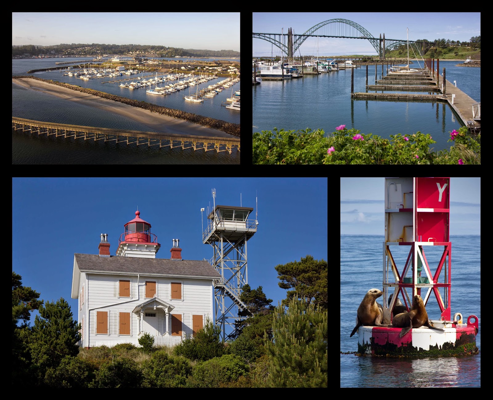
Newport is a quiet coastal town, and the relaxed pace of
life was a refreshing change from the hustle and bustle of San Francisco. It is home to one of the largest commercial
fishing fleets in Oregon and the fishing port in the historic Bayfront area was
often busy with ships coming and going, unloading their catch of crab, tuna,
halibut, and rockfish. Crab pots lined the
edges of the harbor entrance and went for miles up and down the coast. At minus tides, hundreds of people were often
out clamming in the mud flats under the bridge.

A week after we arrived, our friends Eric, Cristi, and their
kids, Jadyn and Logan, came down from Seattle to spend Memorial Day weekend
exploring the Oregon coast. They picked
us up, and we headed south near Florence for a dune buggy tour in the Oregon
Dunes National Recreation Area, the largest area of coastal dunes in North
America. Some of these dunes are 500
feet tall, and our driver took us on an exhilarating ride at speeds up to 60
mph. It seemed certain the buggy would
flip over time and again, and we were glad we didn’t do it on a full stomach. The next several days were spent hanging out
with our friends and exploring the beautiful Oregon beaches. It felt good to be back in the Pacific
Northwest again.

Our plan was to continue north the next week, but the
weather did not cooperate. Strong
northwest winds were blowing, which would have made for a slow and miserable
passage up the coast. As we started to become
impatient, we thought back to our trip down the coast four years prior. That was the most uncomfortable passage of
our entire circumnavigation, with big seas and very cold and wet
conditions. It was a lesson learned the
hard way right off the bat, and our understanding of weather systems and choosing
to wait for the right conditions before leaving port has kept us alive and
Saviah unscathed so far.
Fortunately, if you get stuck on the coast somewhere,
Newport is definitely the place to be.
There is a marina with very reasonable rates located right next to the
Rogue Brewery. The city loop bus service
runs every few hours, where we could catch a free ride into town for groceries
and other shopping. They also have
beautiful beaches running for miles to the north and south of town.
One of the highlights of our stay was a trip out to the Yaquina
Head Lighthouse, just a few miles to the north.
It was a bit of a hike from the marina but well worth it. Walking trails near the lighthouse lead up to
vistas of the cape, and there are numerous tide pools to explore at low
tide.

Since this window was only a few days, we decided to get a
jump on it to ensure we would make it beyond the bar and up into the Strait of
Juan de Fuca, 240 miles away, before the winds picked up again. As we left, the northwest winds were still
blowing at 10-15 knots with a five foot choppy swell, and it took some time to
get our sea legs after a month in the calm of the marina. By the second morning, conditions had
moderated, and we motor-sailed along in relative comfort. Conditions remained calm for the next two
days, but a low was approaching Vancouver Island, BC. After rounding Cape Flattery, we headed east
into the Strait of Juan de Fuca to Port Angeles to wait for the low to pass.
After two nights in Port Angeles, the weather cleared up, and we set sail again. Rather than go straight back to Seattle, we decided to do one last side trip. For years, we had been hearing about a place called the Princess Louisa Inlet in British Columbia, and it seemed like a good time to see it. With three days of really nice weather in the forecast, we wanted to get there as quickly as possible. We left at first light and sailed north across the Strait of Juan de Fuca, through the San Juan Islands and into Bedwell Harbor on South Pender Island, arriving early that afternoon. It was just a quick stop to clear Canadian customs, and we were underway again an hour later.

We continued north through the night, making it across the Strait of Georgia before sunrise. By this point, we were ahead of schedule and slowed our pace for the last 45 miles up the Jervis Inlet. There was no reason to rush, as the plan was to transit Malibu Rapids at high slack tide late that afternoon. The scenery along this stretch was really beautiful with many snow-capped mountains towering in the background. It was especially nice to be back in protected waters again, after months of working our way up the Pacific coast.

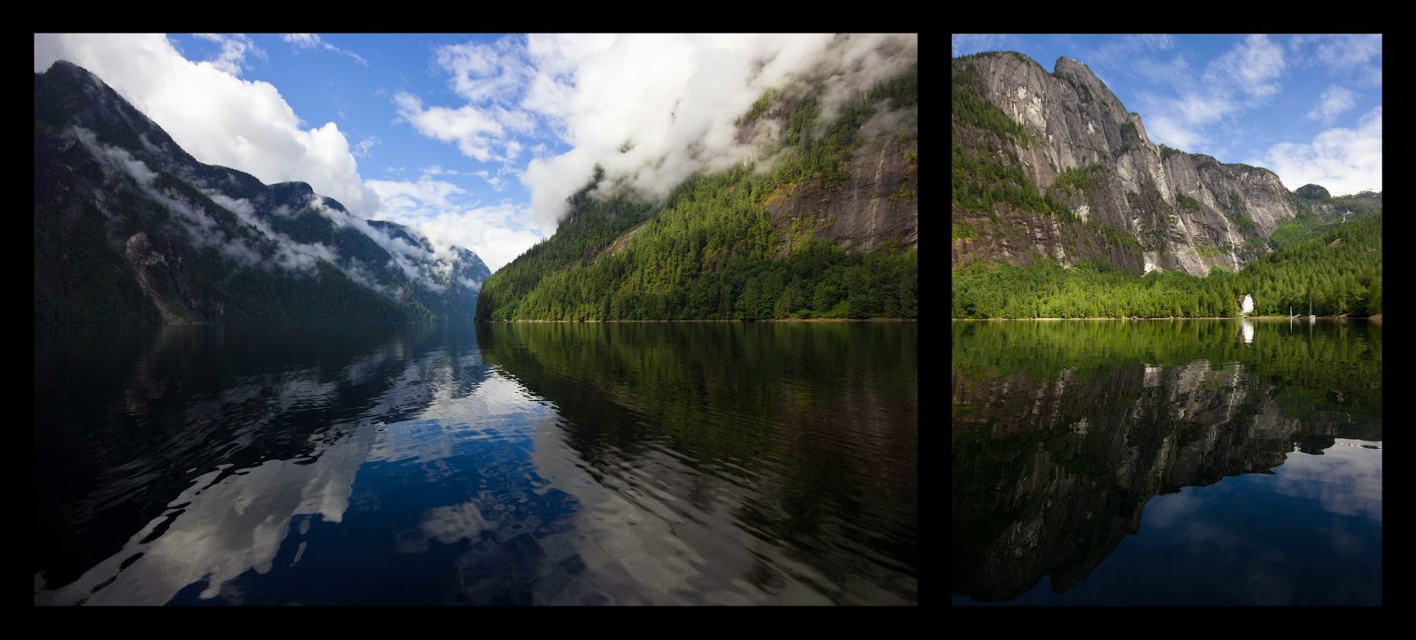
The Jervis Inlet is a fjord that starts 60 miles north of Vancouver, BC and zig-zags for about 50 miles inland. The fjord is beautiful and pristine, as population is sparse since there is no road access to the area. About five miles before the end of Jervis Inlet, it intersects with another four mile long inlet. This is the Princess Louisa Inlet and accessing it involves transiting the Malibu Rapids, the very narrow entrance, where the two inlets meet. As the tide rises and falls, there can be quite a bit of current, as well as overfalls.
We arrived at Malibu Rapids right before slack tide and announced on the VHF that Saviah was heading through the pass, which is the usual protocol since it would be dangerous to try to pass another vessel. Even at the reported slack time, we had a knot of current with us, and it was easy to see how this narrow passage could become treacherous with a full tidal current of nine knots gushing through it.
The last four miles to the head of the fjord were absolutely stunning. The narrow waterway is lined by cliff walls rising straight up and dozens of waterfalls cascading down. The Princess Louisa Marine Provincial Park controls the area and has provided a 200 foot long dock and a small campground at the end near Chatterbox Falls.
As we approached Chatterbox Falls, we were happy to see only a few boats on the dock, which is often full during the summer months. Saviah coasted alongside, and we had the best seat in the house with our stern facing the falls.

We spent the evening enjoying the view and the peacefulness of the park. The next day, we hiked up to the old trapper’s cabin above the falls. It was a strenuous one and a half hour hike nearly straight up, but the reward was a bird’s eye view of the inlet. By the time we returned to Saviah, only one other boat remained on the dock, and we had a great afternoon rowing around the inlet and enjoying the quiet wilderness. Late that afternoon, at slack tide, the next group of boats came in and quickly filled up the entire dock, just as it began to rain. We felt fortunate to have had a full day there with perfect weather and very few people. It is certainly one of the most beautiful places we’ve seen yet.
The next morning, we set off for Pender Harbor, 45 miles
away. This time we passed through Malibu
Rapids near low slack water. We were a little
early, and the tide was flowing a few knots against us. This made for a stressful transit, as Andrew struggled
to maintain steerage at times, and we got a little too close to shore. Once through the rapids, it was an uneventful
trip, reaching the Fisherman’s Marina in Pender Harbor around 8 pm.
This was a quiet harbor, and we took care of some boat chores and did a nice hike up to the top of Pender Hill which afforded great views of the bay and islands. We spent two nights there and then set out across the Strait of Georgia to Vancouver Island. After a night in the Nanaimo marina, we moved over to a mooring buoy at nearby Newcastle Island. We then continued south, stopping at Silva Bay on the tip of Gabriola Island and then off to a small quiet anchorage between the Secretary islands. This was a small bay with not much room to swing, so we anchored out and tied a stern line to shore to keep the boat in place.
 |
| Pender Harbor, Newcastle Island, and anchorage between Secretary Islands |
On June 30th, we arrived in Ganges on Salt Spring
Island and anchored out in the bay. Our plan was to stay only one night, but we
decided to stay an additional day when we realized that July 1st was
Canada Day, and they had all sorts of festivities, including a car show and
fireworks the next night.

The next stop was Montague Harbor, on the south east side of Galliano Island, where we picked up a mooring at the provincial park. Our friends Eric, Cristi, and their kids came up for a long weekend, and we had a great time buddy boating through the Gulf Islands, with stops at Otter Bay on North Pender Island, Lyall Harbor on Saturna Island, and Bedwell Harbor on South Pender Island.

From there, we returned to the San Juan Islands and cleared customs at Friday Harbor before moving on to Fisherman’s Bay on Lopez Island for a night. The bay is quite shallow, and we found an anchor spot in 12 feet of water just off the marina. The next morning, our friends headed back to Seattle, and we rented bikes and spent the day riding around the island. We departed early the next morning and had a really nice sail across the Strait of Juan de Fuca, arriving in Port Townsend that afternoon. It was exciting to return to one of our favorite ports in the Puget Sound.
We spent two nights there before starting our last leg back to Seattle on the morning of July 10th. We had beautiful sunny weather for the 37 mile trip and arrived back at Elliott Bay Marina, near downtown Seattle, early that afternoon. The feeling was a little bittersweet after our great adventure. It is hard to believe that we barely knew how to sail four years ago, and since then, we covered 35,000 miles, crossing three oceans and visiting 30 countries.
Soon, we’ll have to start transitioning our lives from cruisers to landlubbers. It will be time to polish up our résumés, start the job search, and buy a car. But we can deal with those things later. For now, it is so good to be home!
