Tuesday, August 5, 2014

Oregon, British Columbia, and back to Seattle (2014)

We set off from San Francisco Bay on May 13th, hoping to make it as far north as possible before the typical northwesterly winds picked up again.  The weather forecast showed very light winds and mild swell for the following five days.  This stretch of coastline can be treacherous, as strong winds and steep seas occur frequently.  Ports of refuge become fewer as one proceeds north, and most have sandbars in front of the entrance, making it dangerous to arrive during periods of rough weather.  This makes it even more important to monitor the forecast and run for cover before bad weather arrives.

After four uneventful days, we covered 470 miles, and the forecast showed conditions would be deteriorating soon.  We decided to stop in Newport, Oregon and wait for the next window to make the remaining hop up the Oregon and Washington coast.   


Newport is a quiet coastal town, and the relaxed pace of life was a refreshing change from the hustle and bustle of San Francisco.  It is home to one of the largest commercial fishing fleets in Oregon and the fishing port in the historic Bayfront area was often busy with ships coming and going, unloading their catch of crab, tuna, halibut, and rockfish.  Crab pots lined the edges of the harbor entrance and went for miles up and down the coast.  At minus tides, hundreds of people were often out clamming in the mud flats under the bridge.


A week after we arrived, our friends Eric, Cristi, and their kids, Jadyn and Logan, came down from Seattle to spend Memorial Day weekend exploring the Oregon coast.  They picked us up, and we headed south near Florence for a dune buggy tour in the Oregon Dunes National Recreation Area, the largest area of coastal dunes in North America.  Some of these dunes are 500 feet tall, and our driver took us on an exhilarating ride at speeds up to 60 mph.  It seemed certain the buggy would flip over time and again, and we were glad we didn’t do it on a full stomach.  The next several days were spent hanging out with our friends and exploring the beautiful Oregon beaches.  It felt good to be back in the Pacific Northwest again.


Our plan was to continue north the next week, but the weather did not cooperate.  Strong northwest winds were blowing, which would have made for a slow and miserable passage up the coast.  As we started to become impatient, we thought back to our trip down the coast four years prior.  That was the most uncomfortable passage of our entire circumnavigation, with big seas and very cold and wet conditions.  It was a lesson learned the hard way right off the bat, and our understanding of weather systems and choosing to wait for the right conditions before leaving port has kept us alive and Saviah unscathed so far.

Fortunately, if you get stuck on the coast somewhere, Newport is definitely the place to be.  There is a marina with very reasonable rates located right next to the Rogue Brewery.  The city loop bus service runs every few hours, where we could catch a free ride into town for groceries and other shopping.  They also have beautiful beaches running for miles to the north and south of town.

One of the highlights of our stay was a trip out to the Yaquina Head Lighthouse, just a few miles to the north.  It was a bit of a hike from the marina but well worth it.  Walking trails near the lighthouse lead up to vistas of the cape, and there are numerous tide pools to explore at low tide.   

After waiting for a month in Newport, twice as long we had ever waited for weather before, we finally had a decent window on June 17th.  The next section up the coast has even fewer ports of refuge, and the inshore route passes near the Columbia River Bar.  This is where Columbia River flows out into the Pacific at four to seven knots against the prevailing westerly quadrant winds and swells, and the sea state can become quite dangerous for many miles offshore during the ebb tide.  It is called the graveyard of the Pacific, since over 2,000 large ships have sunk there.   Our goal was to transit this area in calm conditions, preferably at slack or flood tide.
   
Since this window was only a few days, we decided to get a jump on it to ensure we would make it beyond the bar and up into the Strait of Juan de Fuca, 240 miles away, before the winds picked up again.  As we left, the northwest winds were still blowing at 10-15 knots with a five foot choppy swell, and it took some time to get our sea legs after a month in the calm of the marina.  By the second morning, conditions had moderated, and we motor-sailed along in relative comfort.   Conditions remained calm for the next two days, but a low was approaching Vancouver Island, BC.  After rounding Cape Flattery, we headed east into the Strait of Juan de Fuca to Port Angeles to wait for the low to pass. 

After two nights in Port Angeles, the weather cleared up, and we set sail again.  Rather than go straight back to Seattle, we decided to do one last side trip.  For years, we had been hearing about a place called the Princess Louisa Inlet in British Columbia, and it seemed like a good time to see it.  With three days of really nice weather in the forecast, we wanted to get there as quickly as possible.  We left at first light and sailed north across the Strait of Juan de Fuca, through the San Juan Islands and into Bedwell Harbor on South Pender Island, arriving early that afternoon.  It was just a quick stop to clear Canadian customs, and we were underway again an hour later.


We continued north through the night, making it across the Strait of Georgia before sunrise.  By this point, we were ahead of schedule and slowed our pace for the last 45 miles up the Jervis Inlet.  There was no reason to rush, as the plan was to transit Malibu Rapids at high slack tide late that afternoon.  The scenery along this stretch was really beautiful with many snow-capped mountains towering in the background.  It was especially nice to be back in protected waters again, after months of working our way up the Pacific coast.   


The Jervis Inlet is a fjord that starts 60 miles north of Vancouver, BC and zig-zags for about 50 miles inland.  The fjord is beautiful and pristine, as population is sparse since there is no road access to the area.  About five miles before the end of Jervis Inlet, it intersects with another four mile long inlet.  This is the Princess Louisa Inlet and accessing it involves transiting the Malibu Rapids, the very narrow entrance, where the two inlets meet.  As the tide rises and falls, there can be quite a bit of current, as well as overfalls.

We arrived at Malibu Rapids right before slack tide and announced on the VHF that Saviah was heading through the pass, which is the usual protocol since it would be dangerous to try to pass another vessel.  Even at the reported slack time, we had a knot of current with us, and it was easy to see how this narrow passage could become treacherous with a full tidal current of nine knots gushing through it. 

The last four miles to the head of the fjord were absolutely stunning.  The narrow waterway is lined by cliff walls rising straight up and dozens of waterfalls cascading down.  The Princess Louisa Marine Provincial Park controls the area and has provided a 200 foot long dock and a small campground at the end near Chatterbox Falls. 

As we approached Chatterbox Falls, we were happy to see only a few boats on the dock, which is often full during the summer months.  Saviah coasted alongside, and we had the best seat in the house with our stern facing the falls.


We spent the evening enjoying the view and the peacefulness of the park.  The next day, we hiked up to the old trapper’s cabin above the falls.  It was a strenuous one and a half hour hike nearly straight up, but the reward was a bird’s eye view of the inlet.  By the time we returned to Saviah, only one other boat remained on the dock, and we had a great afternoon rowing around the inlet and enjoying the quiet wilderness.  Late that afternoon, at slack tide, the next group of boats came in and quickly filled up the entire dock, just as it began to rain.   We felt fortunate to have had a full day there with perfect weather and very few people.  It is certainly one of the most beautiful places we’ve seen yet.


The next morning, we set off for Pender Harbor, 45 miles away.  This time we passed through Malibu Rapids near low slack water.  We were a little early, and the tide was flowing a few knots against us.  This made for a stressful transit, as Andrew struggled to maintain steerage at times, and we got a little too close to shore.  Once through the rapids, it was an uneventful trip, reaching the Fisherman’s Marina in Pender Harbor around 8 pm.

This was a quiet harbor, and we took care of some boat chores and did a nice hike up to the top of Pender Hill which afforded great views of the bay and islands.  We spent two nights there and then set out across the Strait of Georgia to Vancouver Island.  After a night in the Nanaimo marina, we moved over to a mooring buoy at nearby Newcastle Island.  We then continued south, stopping at Silva Bay on the tip of Gabriola Island and then off to a small quiet anchorage between the Secretary islands.  This was a small bay with not much room to swing, so we anchored out and tied a stern line to shore to keep the boat in place. 

Pender Harbor, Newcastle Island, and anchorage between Secretary Islands
On June 30th, we arrived in Ganges on Salt Spring Island and anchored out in the bay.   Our plan was to stay only one night, but we decided to stay an additional day when we realized that July 1st was Canada Day, and they had all sorts of festivities, including a car show and fireworks the next night. 


The next stop was Montague Harbor, on the south east side of Galliano Island, where we picked up a mooring at the provincial park.  Our friends Eric, Cristi, and their kids came up for a long weekend, and we had a great time buddy boating through the Gulf Islands, with stops at Otter Bay on North Pender Island, Lyall Harbor on Saturna Island, and Bedwell Harbor on South Pender Island. 


From there, we returned to the San Juan Islands and cleared customs at Friday Harbor before moving on to Fisherman’s Bay on Lopez Island for a night.  The bay is quite shallow, and we found an anchor spot in 12 feet of water just off the marina. The next morning, our friends headed back to Seattle, and we rented bikes and spent the day riding around the island.  We departed early the next morning and had a really nice sail across the Strait of Juan de Fuca, arriving in Port Townsend that afternoon.   It was exciting to return to one of our favorite ports in the Puget Sound.

We spent two nights there before starting our last leg back to Seattle on the morning of July 10th.  We had beautiful sunny weather for the 37 mile trip and arrived back at Elliott Bay Marina, near downtown Seattle, early that afternoon.  The feeling was a little bittersweet after our great adventure.  It is hard to believe that we barely knew how to sail four years ago, and since then, we covered 35,000 miles, crossing three oceans and visiting 30 countries. 

Soon, we’ll have to start transitioning our lives from cruisers to landlubbers.  It will be time to polish up our résumés, start the job search, and buy a car.  But we can deal with those things later.  For now, it is so good to be home!


Friday, June 6, 2014

California (2014)

On the afternoon of March 12th, Saviah went back in the water after a week in the boatyard at the Baja Naval Marina in Ensenada.  A few hours later, just before sunset, we had everything stowed and pulled out of the harbor to make the 60 mile passage to San Diego.  It was an uneventful trip, motor-sailing in the light NW winds and flat seas, and we arrived at the police docks in San Diego around 6 am.  The customs officers arrived 30 minutes later and cleared us into the country.  There was no boat inspection required, just a little bit of paperwork, and we were done.  Saviah had officially returned to her home country.

After the sun came up, we set off for the familiar docks of the Harbor Island West Marina. We had done quite a bit of sightseeing on our previous stay three years ago, and this time our focus was on taking care of some boat projects.  It had been a long time since we had been to a chandlery with the prices and selection available in the US, and we were looking forward to updating a few things.  We did find time to spend a day walking along the waterfront and touring some of the classic sailing ships and the maritime museum as well. 

marinas at Harbor Island, classic sailing ships on the San Diego waterfront

During our many trips to the chandleries, we bought new fire extinguishers and flares to replace our expired ones, a new strobe light, and many other odds and ends.  We also needed to get some new charts and guidebooks since our journey up the coast would involve stopping often.  Another project was to clean out the storage lockers and cubbies on Saviah to get rid of stuff we didn’t need and also swap out our anchors.  Our primary anchor was still a 55 pound Delta that was too big for our boat and a pain to pull in by hand.  Our backup was a knock off CQR that was the only one we could find in American Samoa, and we were never able to get it set.  The flukes on our 35 pound Danforth were stuck in place, and no amount of pounding was able to break them loose enough to function properly.

We were excited to learn that Enterprise still has their $10/day weekend special, which we took advantage of several times going up the coast.  We picked up a car, loaded up the trunk with boat stuff and drove around to several of the second hand stores, including the huge Minney’s store 90 miles north in Costa Mesa.  We were able to trade our old anchors, charts, guidebooks and other stuff that we no longer needed.  In the end, we ended up with a 45 pound Bruce anchor as a back-up and a 45 pound Delta for the primary, some extra cash and a lot of extra room in the boat.  While we had the rental car, we drove out to Cabrillo National Monument on Point Loma to see the lighthouses and take in the views.


We spent a week in San Diego and then left on March 20th at 5 am for the 80 mile sail to Catalina Island.  Our speed wasn’t quite fast enough to make it to Two Harbors before the sun went down, so we took the first mooring buoy that we could find along the east side of the island.  It took about 30 minutes to get all of the lines secured in the dark, and the next morning we untied to make the short hop up to Isthmus Cove.

This part of Catalina Island is very different from Avalon, the bustling harbor we visited three years ago on our way down the coast.  The small town of Two Harbors is located on the narrow strip of land found between Isthmus Cove to the north and Catalina Harbor to the south.  Since it is not far from LA, it can get crowded in the summer, but it was quiet during our stay, and in the offseason, you get five days on the moorings free when you pay for two. 

Catalina Island

The weather was sunny and clear for our first few days, so we hiked around, exploring the many trails in the area.  The island is quite steep and the trails along the ridgeline around 1,500 feet provided some great views.  We could clearly see the California coast, 20 miles away.   Unfortunately, the forecast didn’t look good for the coming days, so we took advantage of our last day of calm weather to make another hop up the coast.  We had considered going to LA, but the transient dock at Marina Del Rey was under construction for the entire month, so we made the 85 mile sail to Santa Barbara instead.
  
Saviah slipped the mooring lines at 6 pm and arrived in Santa Barbara the next day around noon.  The seasonal anchorage was closed until April 1st, so we took a slip in the marina there.  It was a bit expensive, so we hoped to stay for only a few days before continuing on our way.  The next leg of our journey would be the 100 mile passage to Morro Bay, which involves rounding Point Conception, a notoriously windy point with rough seas.  We needed a window of calm for this trip, and it became obvious that our wait would be much longer than the few days we had planned. 

Santa Barbara marina

Other than the expensive marina, Santa Barbara is not a bad place to be stuck waiting for weather.  It is a beautiful city with a paved coastal trail that goes for miles both east and west of the marina.  The trail was perfect for running, and we made it part of our daily routine.  There were nice beaches in both directions as well, and downtown was only a 20 minute walk away.  We even rented a car again and drove through the Santa Ynez Valley, visiting the quaint towns and enjoying being off the boat for a couple of days.

Santa Barbara

We ended up staying in Santa Barbara for 11 days before we had a decent weather window and headed out at 4 am on April 3rd.  Our plan was to sail 40 miles to the Cojo Anchorage, just east and in the lee of Point Conception.  We would then anchor there for the rest of the day and head off again at midnight to get around the point in the wee hours of the morning when conditions are usually the lightest.

Point Conception
As we neared the Cojo Anchorage, the seas were benign, and it didn’t make sense to stop.  We continued up the coast monitoring the weather and rounded Point Conception at noon on a beautiful calm sunny day.  We continually waited for the wind to increase and seas to build, but it just didn’t happen.  The same calm conditions persisted for the remaining 60 miles to Morro Bay, although the temperatures are getting colder as we make our way north, especially after the sun sets.  Night watches seem very long, and it is hard to stay warm, even wearing three jackets. 

We arrived around midnight, and Di called the Coast Guard station to check the entrance conditions.  With the all clear, we proceeded into the bay at high slack tide, dropped the hook in 15 feet, and got a good night’s sleep.  We knew there was a large shoal area west of where we anchored that dries at low tide, but in the morning we were surprised to see how close it was.  There was a bird standing on the ground about 30 feet from Saviah’s stern.   We turned on the depth sounder and it registered around 6 feet, meaning there were only a few inches of water under the keel.

Since the tide was rising we weren’t concerned, but there just wasn’t much swinging room in the bay, which was crowded with boats on mooring buoys.  If there was a good blow, we could get into trouble pretty quick.  So we rowed into town, checked in with the harbor master, and then went down to the Morro Bay Yacht Club to talk to them about staying on a mooring buoy.

Morro Rock and Morro Bay

The Morro Bay Yacht Club has moorings available for transient boats, as well as hot showers, so we moved over later that afternoon.  It was a good decision because the temperatures are getting colder and access to shore side facilities is hard to resist, especially without a water heater on board.  The yacht club members were very welcoming and even invited us to join their Friday afternoon happy hour.

Morro Bay was a good stop for us.  We enjoyed walking around town and on the beach that stretches for almost six miles north of Morro Rock (the 576 foot high volcanic plug that sits at the entrance of the harbor).  We also spent some time rowing around in the protected bay where they have a dock, which is nearly sinking from the weight of all the sea lions.  One of the babies was really interested in us and nearly boarded the dinghy.  We also saw sea otters for the first time.  There are dozens of them in the bay, and for much of the day, they can be found close to shore in the kelp beds.  They wrap themselves up in the kelp so they can sleep without drifting off.


We stayed in Morro Bay for three days before there was another round of good weather offshore. We untied the mooring lines in the middle of the afternoon and made the 100 mile hop north to Monterey overnight.  This was another nerve racking trip in dense fog that set in several hours out of port and only cleared when we neared Monterey around noon the next day.  Shortly after the fog set in, one of two radar reflectors, which are mounted to the upper shrouds near the top of the mast, fell down and almost landed on Di in the cockpit.  The hard plastic shattered into hundreds of sharp pieces and flew all over the boat, inside and outside.  It was a close call, and we made it a priority to replace the cable ties securing the other radar reflector as soon as we were in port.

We took a slip in the Monterey Municipal Marina and really enjoyed our stay there.  There is a coastal trail leading from the marina past the pier at Fisherman’s Wharf, with dozen of shops and restaurants, and then further to Cannery Row, where there was a huge fishery before the business collapsed in the 1950’s due to overfishing.  Beyond that, the trail continued along to nearby Pacific Grove where the harbor seals and their pups lounged on the beaches and beautiful pink wildflowers lined the coast. 


The marine life in Monterey Bay is prolific.  In the middle of the bay is Monterey Canyon, one of the largest underwater canyons in the world, at over two miles deep in places.  Its depth and nutrient availability provide an excellent environment for all sorts of whales, dolphins, seals, sea lions, otters, and others.  There were sea otters swimming around Saviah in the marina and even lounging on the dock next to her.


After waiting for weather for a while with no window in sight, we rented a car to explore the coast.  We drove through Big Sur, where Highway 1 winds high along the cliffs that drop straight down hundreds of feet into the ocean.  Another day was spent visiting the north side of the bay to check out the town of Santa Cruz, with its beachfront amusement park.  We then drove inland a bit so we could squeeze in a half-day hike in the Santa Cruz Mountains. 


After almost two weeks in Monterey, we had a short weather window that would allow us to make the 65 mile sail to Half Moon Bay.  It wasn’t ideal, but if we left in the middle of the night, we could take advantage of the calmer conditions and arrive before the next strong blow.  We left Monterey at 2 am, motor-sailing with NW winds at 5-10 knots.  As predicted, the large westerly swell from a storm system off Canada had finally made its way to the California coast.  We started seeing long rolling 10-12 foot seas, and as we approached Half Moon Bay, the wind kicked up to NW 15-20.

The approach to the harbor has several reefs to be avoided, which were easy to see with the massive waves breaking on them.  It was a bit nerve wracking approaching the entrance in the large swell, which was with us all the way to the harbor breakwall.  Once we rounded the jetty, we reached the flat water of the harbor and doused the main, finding a good anchor spot just west of the marina breakwater.  After the anchor was set, we unloaded the dinghy and rowed to shore to check out the town before the winds picked up.  We made the four mile walk to town along the coastal trail.  It was foggy and cold, but a beautiful trail with wildflowers starting to bloom.

Half Moon Bay

We spent four nights anchored out and then set off for San Francisco Bay on April 24th.  It was only a 25 mile trip to the Golden Gate Bridge and the protected waters of the bay.  As soon as we weighed anchor at 5:30 am, a dense fog rolled into the bay, and we could no longer see the breakwater behind us, or even the navigation lights flashing on top of it.  We let the anchor out again and waited an hour before it thinned out enough to see the harbor entrance.  The winds and seas were fine, but the fog kept us on our toes throughout the trip.  Around noon, we could see parts of the Golden Gate Bridge that was mostly shrouded in fog, but as soon as we passed under it, the skies cleared and the wind picked up to 15 knots from the NW.  We unfurled the genoa and had a great sail through the bay.


Before leaving Half Moon Bay, we were weighing our options for moorage in the Bay Area, which can be really pricey, when Andrew saw an ad in a sailing magazine for the Brisbane Marina. We called and found out that it was only $10/day, the cheapest we have paid anywhere in the world.  Since Andrew’s brother Adam was coming to visit and we would be staying for at least a week, we decided this would be a good place to stay.  We sailed past San Francisco and then headed about 10 miles south of downtown.
 
Our arrival in Brisbane was a little off, and we transited the dredged channel at low tide.  Our depth sounder read 6.3 feet, so Saviah’s keel was just barely above the mud bottom.  The afternoon winds had kicked up to 20-25 knots, but luckily the 200 foot guest dock was empty giving us plenty of room to pull alongside and get settled.  We liked the Brisbane Marina, which had all the amenities, but it was a long way from anything.  It was a 40 minute walk just to get to the bus stop, so getting groceries was an all-day affair.

We were planning to rent a car for Adam’s visit, so we decided to just tack a couple days on to the beginning and run some errands.  Other than grocery shopping, there was another boat project to do, which was upgrading our propane tanks.  We weren’t aware until recently that our fiberglass propane tanks had been recalled and the company went out of business.  We could still have them filled south of the border, but back in the US we weren’t having any luck and our propane was running low.
 
Since our propane locker was custom built for these unusually sized tanks, a conventional tank wouldn’t work, but we were able to find some steel tanks at the nearby West Marine that fit fairly well.  Disposing of our old ones was a bit harder.  None of the landfills would take them since we weren’t residents of the county.  After dozens of phone calls, we eventually found a hazardous waste site about 15 miles south that would take the old ones and dropped them off.

We were looking forward to Adam’s visit, and he finally arrived on May 3rd for a one week trip.  He had never been to the Bay Area before and had a list of places he wanted to see in San Francisco and around the region.  The day after he arrived, we headed south down the coast and stopped in Monterey, did the Seventeen Mile Drive through Pebble Beach and Carmel, and then continued along Highway 1 down the coast through Big Sur.   We spent the night in San Simeon and the next morning did a tour of the Hearst Castle, which is the 90,000 square foot mansion built by William Randolph Hearst  between 1919 and 1947.

Highway 1 along Big Sur, lone pine at Pebble Beach, Hearst Castle

After San Simeon, we headed back north to San Francisco to explore the city, visiting many of the well-known San Francisco icons, including Coit Tower, Lombard Street, Fisherman’s Wharf, Pier 39, Chinatown, and a few museums as well.  The weather was fairly nice, so we did some hikes around the Golden Gate National Recreation Area.


The weather in the bay then took a turn to cloudy and rain, so we set off to drive inland through the Napa and Sonoma area north of the city.  We had a beautiful drive through the vineyards and also made a stop in Muir Woods and Sausalito on the way back. 

Napa Valley and Golden Gate Bridge

A week flew by, and after dropping Adam off at the airport, we reluctantly shifted out of tourist mode and into passage mode.  We prepared Saviah for our next hop up the coast.  The ports become fewer and farther between on this stretch, and we hoped to find a long window and cover as much ground as possible.  Surprisingly, it was only a few days before we had what looked like a great window, and off we went with our target port Newport, Oregon, 470 miles away.

sailing out under Golden Gate Bridge, Bay Bridge and by Alcatraz Island and Point Bonita Lighthouse

Wednesday, April 23, 2014

Mexico (2013-2014)


On November 5th, after a few weeks in El Salvador, we left Bahia del Sol for the next leg north.  Earlier that morning, we cleared out at the customs and immigration offices on-site and walked to the beach to check out the breakers in front of the estuary.  They were big and steep, which made us a bit apprehensive, but it was low tide, and we wouldn’t be leaving until high tide late that afternoon. 

On the way into the estuary, we had surfed down several decent size waves.  It wasn’t so bad going with the waves, but going the opposite direction, it would have been rough.  Fortunately, by the time high tide rolled around at 3 pm and we followed our pilot boat out, the swell had died down considerably.  The waves were around five feet, but well-spaced and not really breaking, so it was actually less exciting than coming in.  We followed the instructions from the pilot boat and before we knew it, the sand bar was behind us, and we set our course for Puerto Madero, Mexico, 250 miles away.

For most of the trip, winds were from the west at 5 knots, so we motor-sailed with just the main up.  The current was against us, so our speed was slow at 4 knots, but it was a relatively pleasant passage as most of the nightly thunderstorms missed us.  We neared Puerto Madero early on 
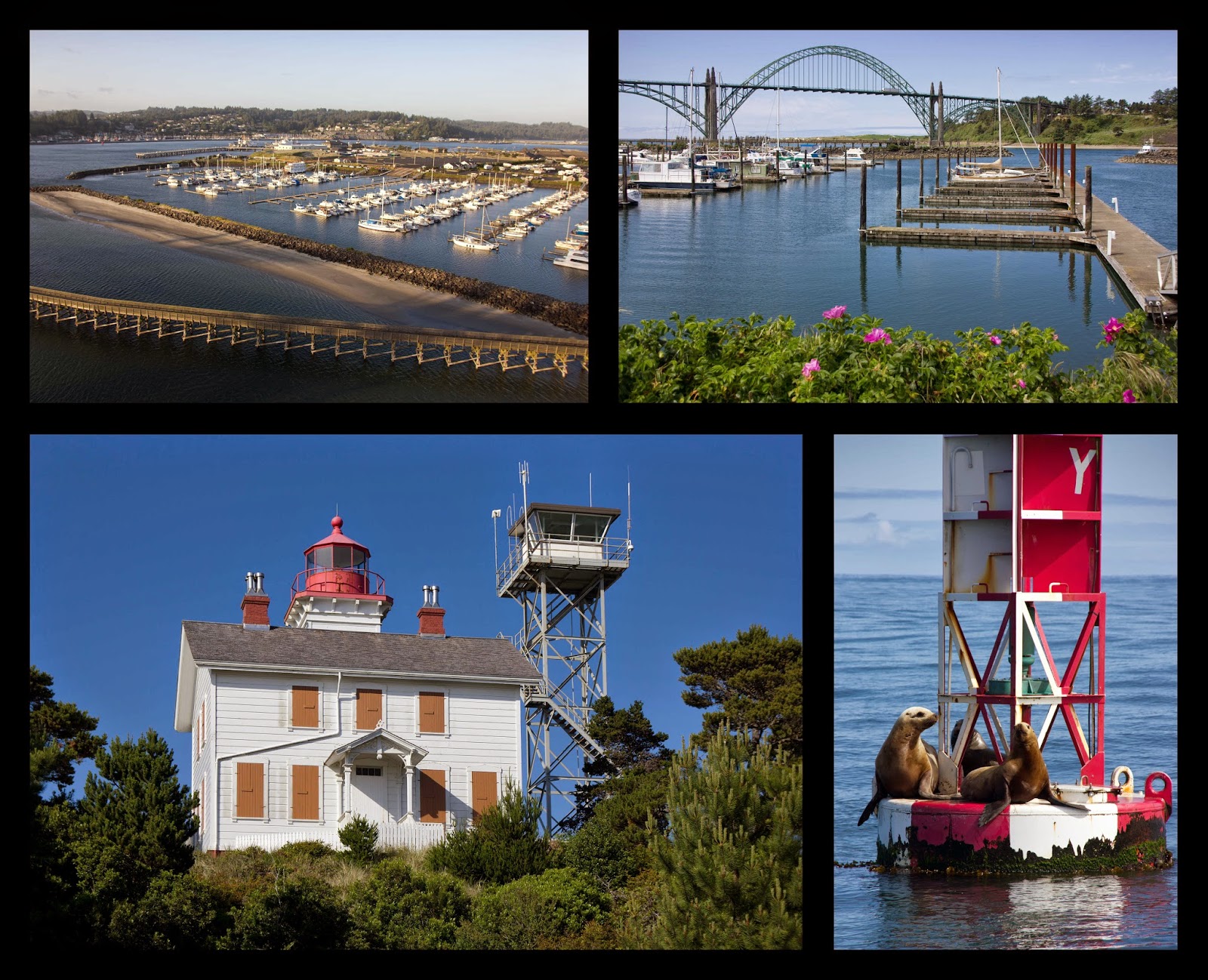
November 8th, and the sun rose just was we entered the harbor.  Saviah coasted into a slip at Marina Chiapas, happy to be back in Mexico.

The marina staff was very welcoming and called the Navy, who arrived an hour later to do their paperwork and quick inspection.  We then checked in with the marina office, where the manager Enrique handled the rest of our clearance paperwork and even drove us to the airport later that afternoon to complete our immigration clearance. 

Chiapas is the most southern state in Mexico, and Puerto Madero is a great place to enter the country for northbound vessels.  The clearance process is easy, thanks to the marina’s help, and it is a great spot to wait for weather before tackling a potentially difficult next leg, which involves crossing the Gulf of Tehuantepec.  The Tehuantepec is known for its blustery winds and dangerous sea state.  From October to April, the gulf regularly has violent gales, referred to as Tehuantepecers.  These are strong north winds that blow in from the Gulf of Mexico and funnel through the Chivela Pass, intensifying as they reach the Pacific.  These strong winds reach hundreds of miles offshore, and create big, steep seas as they blow over the shallow gulf waters.

We downloaded weather forecasts daily, looking for the next available window.  We debated about doing some more land travel, as there are many sites to see in Chiapas, including several large Mayan ruins and some colonial cities that we had heard good things about.  We wanted to head north as soon as weather permitted, and decided it was better to hang around the boat to be ready.  So we caught up on a few boat projects and did a lot of provisioning as well.

Although the nearest town is 30 miles away, the marina manager, Enrique, gave us a ride in during his trip home for lunch just about every day.  There was a Super Walmart in town, and it had been a long time since we’ve been in a store with so much to choose from.  It was nice to have so many options for meals again, and we stocked up.  There was also a Home Depot nearby where we made one of our best purchases ever, a box fan.  The heat here was almost unbearable, and the mosquitoes were really bad at night.  Nights aboard Saviah were sweltering until we mounted the fan in the forward hatch.  Even with all the mosquito netting up, the fan provided a good breeze through the boat, and it made a world of difference. 

After a week in Chiapas, the 50-60 knot winds in the Tehuantepec died down, and the weather forecast showed a two-day window to cross in almost flat calm conditions.  It was time to move on, so we checked out with the marina, had our departure inspection from the Navy, and set off on the 245 mile passage to the Bahias de Huatulco early on November 16th.

There are two strategies for crossing the gulf, depending on the weather forecast.  One strategy is to sail a direct course across when you have a solid forecast for at least two days of calm conditions.  The other is the “one foot on the beach” method, which is the more commonly used strategy when there is uncertainty about the weather.  This option would have us sail along the 30 foot contour line, except to clear a few headlands with shoals extending further offshore.  By doing this, it increases the mileage, but if the wind starts to blow you can stay in relatively flat waters.  It also means that we would be sailing VERY close to shore at night, where there are unlit hazards to deal with, especially fishing nets.  

There was still a little uncertainty in the forecast, so we decided to do a modified one foot on the beach approach.  Our course kept us about five miles offshore, and we monitored the weather continually, ready to alter course for shore at the first sign of strong winds.  Since we were sailing so close to shore, we were able to get 3G service on our cell phone and download weather forecasts.  This was a first, and it made the passage a lot less stressful.  The winds were benign throughout the passage, and we had a favorable current for much of the trip as well.  We arrived at Bahias de Huatulco earlier than expected and hove to for five hours until the sky began to lighten. 

We decided to stop for fuel and rest and pulled into Marina Chauhue near Santa Cruz, just as the sun rose.  After a couple days, we were off again for the 355 mile trip to Zihuatanejo.  This three-day trip was an easy motor-sail in light winds, and we again arrived at night and hove-to for about five hours to wait for the sun to come up. 

Years ago, Zihuatanejo was a sleepy fishing village.  In the 70’s, the government decided to build a modern tourist resort town in Ixtapa, about three miles away.  Since then, Zihuatanejo has grown rapidly, and now tourism is by far the largest industry.  It has still managed to keep a traditional small town feel, and is built around a very well protected bay that is a popular stop for cruisers.  We dropped the anchor in front of Playa Principal, the beach in front of the town center.

Zihuatanejo
 
We spent several days anchored in the bay and exploring the town.  We walked to the central Mercado just about every day for fresh veggies.  Like most of these markets, a wide variety of meats hang from hooks in the warm air.  It is hard to imagine getting used to that smell.  There were also restaurants in the market with really good cheap food, especially the chile rellenos, which we kept coming back for. 

Central Mercado
 
After five days, we were running low on water and anxious to do a few projects that required shore power, so we moved up the coast to the marina at the touristy town of Ixtapa.  The marina there is a little unusual in that there are crocodiles swimming around the fairways.  Several crocodiles swam by Saviah just about every day, and it was a little nerve-wracking walking up the docks, just a foot above the water, knowing that these crocs could easily get up there.  However, the only warnings we received were not to swim in the water.  So far, no incidents with crocs taking people off the docks here like they do in Australia.

Marina Ixtapa, crocodile swimming behind Saviah
 
We didn’t care much for Ixtapa, which was just rows of hotels and shopping centers, but it was a nice place to do some cleaning and small maintenance jobs.  After several days, it was time for a change of scenery, which we found at Isla Grande, just a few miles offshore.  We motored around to the north side of the island and dropped the hook.  It was clear water and a sand bottom, so we went for a quick swim and did some cleaning on the hull and the prop, which was past due.  Then we rowed to shore for some lunch before heading back to the marina that afternoon.

Isla Grande
 
For months, we had been looking forward to a visit from our friends, who would be arriving that afternoon, so we buttoned up Saviah and took a cab back into Zihuatanejo.  Eric and Chris flew in from Seattle and Vermont and had rented a nice condo overlooking the bay for a long weekend.  We spent the next few days hanging out with them and playing tourist.


We did a fishing trip that left early one morning, dragging lines behind a small fishing boat.  We basically just hung out on the boat taking in the scenery, and they would hand us the fishing rod if there was a bite.  After a couple hours, we had three tuna, so we stopped for a snorkel, before our guides took us to a palapa on the beach where they cooked up the fish for us.   We even took turns doing a parasailing trip back in the bay (all except Andrew). 


As always, the time flew by, and we were bidding our friends goodbye.  It was a great long weekend, and always lifts our spirits to see good friends.  With our vacation time over, we shifted focus to the next leg of our voyage.  The weather along this part of mainland Mexico is generally mild, dominated by the daily land and sea breezes, so we didn’t have to wait long for a window.  In the wee hours of December 10th, we set off on the 190 mile trip north and spent one uneventful night at sea before arriving in Manzanillo the next afternoon.

The anchorage here has been a very popular stop for cruisers over the years, because it is right in front of the large Las Hadas resort.  They have a dinghy dock there and for years charged only $2 per day to tie up, and you got to use the resort facilities as well.  Unfortunately, they just increased the price to around $15/day.  We spent the morning walking around town and the afternoon hanging around the resort pool.  One day was enough for us in Manzanillo, and the next morning we weighed anchor to head further north. 

Our next stop up the coast was Bahia Tenacatita.  It was another motorboat ride for all but the last five miles, which we were able to sail in the 15 knot NW winds.  There were six other boats in the anchorage, and we found a nice spot in 15 feet to anchor.  This was a good place to wait for a weather window for the next hop to La Cruz, 135 miles away.  Although the weather is generally benign along this coast, the next leg involved rounding Cabo Corrientes, the point marking the southern end of Bahia de Banderas.  Like all prominent high points that extend into prevailing winds, this cape accelerates the winds and often has confused seas generated by the strong currents flowing around it.  The general rule of thumb is to round these capes in the early morning hours before sunrise to avoid the rougher conditions in late afternoon.

Despite growing tired of motoring, we watched the weather hoping for a window of calm in which to make this transit.  We liked the anchorage here, as it was a quite protected bay with all sorts of marine life in the water.  We were starting to get a little anxious to keep moving though as we had booked flights back to the US for Christmas.  After three nights, we had a window that was less than ideal, but the best we would likely have for the next week, and we decided to go for it.

If we had known what lay ahead, we probably would have opted to stay in the anchorage for a few more days.  Conditions started off comfortable with NW winds at 5-8 knots and calm seas.  Nine hours later, the wind increased to 15-20, gusting 25, with the seas building to 4-6 feet from both the NW and NE.  Saviah bashed along in the rough short period waves until we finally backed off the throttle a little to help with the motion.  We still had 50 miles to go before we were around Cabo Corrientes, and it was going to be a long night.

Throughout the night, the winds shifted between NE and NW, but wind speed stayed at 15-20, gusting 25.  On a downwind course, 4-6 foot seas would be no big deal, but these mixed up and short period waves made Saviah pound, pitch, and heave in the most uncomfortable motion we’ve ever experienced.  Hand-steering and keeping watch was miserable, so we switched every hour in an attempt to stay rested.  What made it even more frustrating was that we were only making 2 -3 knots.

Finally we rounded the cape around 7 am, and conditions gradually moderated until we were motoring in flat calm, having a hard time even keeping the main full.  The last 20 miles across Banderas Bay to La Cruz were sunny and pleasant, no trace of the nasty conditions from just a few hours earlier.  We saw whale after whale on our way, and breathed a big sigh of relief as we approached the marina.  The last time we were here was two years and eight months earlier, when we left Mexico for the sail across the Pacific Ocean.  Since then we have sailed over 28,000 miles, visiting 25 countries along the way.  We tied up in the marina and celebrated officially completing a circumnavigation.   

We arrived in La Cruz almost a week before our flights back to the US.  Our time was spent cleaning and preparing Saviah for a month long stay in the marina, while we were away.  We had lots of laundry to do as well.  After our last bash to windward, we found that most of our clothes in the v-birth were soaked, and it was time to get our foul weather gear out again and clean off the mold.  They would be needed soon as the weather was getting colder with each passage north. 

We also needed to weigh our options for the last leg back to Seattle.  The predominant winds blow from the northwest, all the way back up the coast.  We wouldn’t want to bash against them, but we could hop slowly up the coast, waiting for calm conditions before motoring from port to port.  This would involve many stops along the way and very little sailing.  On the positive side, there are many places that we would like to see all along the coast, and since our plan isn’t to return to Seattle until the beginning of summer, we would have time to wait for the right weather windows. 

The other option would be to sail out to Hawaii and then northeast to Seattle.  This would involve only two long passages, the first would probably be pleasant, but the second half would be cold with less predictable weather.  It would also be more than double the miles, although spending a month or two in Hawaii would not be such a bad thing.  We would need a new genoa as well for this option since ours blew out in the Caribbean, and there would be a lot of downwind miles to Hawaii. 

There would be time to research and weigh our options over the next month as we visited our families back home.  On December 23rd, we flew back to the states, making the usual stops in Texas and New Mexico and enjoyed spending time with our families again. 

We returned to Saviah in mid-January and by that point had decided to get back to Seattle via a coastal hop rather than going to Hawaii.  With this plan, patience is the name of the game, waiting for the right window and then being prepared to leave again when the next one opened.  We did end up finding a genoa when Di ran into Mike at PV Sailing and found that he had several used sails that would work for Saviah.  He gave us a really good price on one, and we took down our small heavy jib and put up the genoa, hoping we would have the opportunity to use it on the way back home. 

Our next leg was the 290 miles from La Cruz to Cabo San Lucas, and after waiting for about a week, had a pleasant two day trip with very light winds and calm seas.  We arrived just in time to tie up the boat, take a quick shower and find a place to watch the Super Bowl.  Go Seahawks!


Our plan was to continue on our way whenever we could, spending as little time in Cabo as possible.  Unfortunately the weather didn’t cooperate, and we ended up spending five days there.  We decided to make the best of it and did a daily hike out to the beautiful beaches and massive rocks on the point at the south end of the bay.  
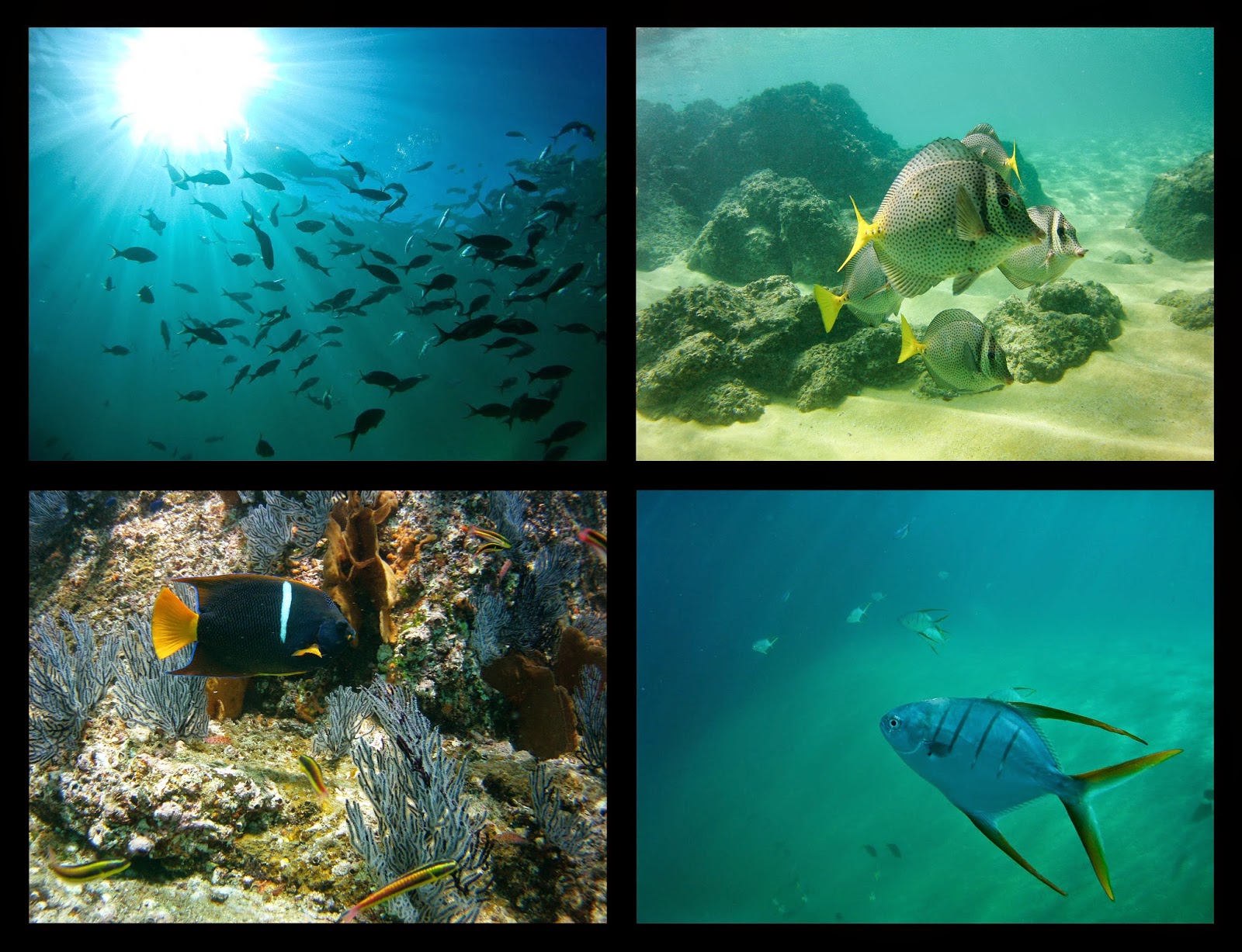
The snorkeling here is nice, too, but the warm tropical waters are apparently behind us, because it is now really cold.  We braved the frigid water a few times since it would likely be our last snorkel for a while.


Since there are no anchorages between Cabo and Bahia Magdalena (commonly known as Mag Bay), we had to tackle the next 175 mile stretch in one leg.  We had read that hugging the coast for the first day keeps you out of the larger seas, so we planned to give this a try.  The forecast showed two days of calm, so we set out on February 7th before dawn.

The forecast was right, and we enjoyed a nice trip motor-sailing in the NW 5 knot winds.  Once we reached Cabo Tosca about 15 miles from the entrance to Mag Bay, the wind died altogether.  Gray whales and dolphins escorted us the rest of the way in, with even more whales inside the bay than outside.  We dropped the anchor in about 12 feet, just barely in the lee of Punta Belcher, where there was one other sailboat. 

Shortly after we dropped the hook, the other boat, Bright Water, hailed us.  Nancy invited us over for drinks, and we gladly accepted.  Taking a shower before going over seemed like the right thing to do, and we found that the water here is even colder.  We will have to be really desperate before taking another outdoor saltwater shower. 

We had a great time chatting with Nancy and Phil, who were heading south, but had ventured back north to Mag Bay to see the whales again.  As we later learned, these two had taken their children on a great adventure in the Caribbean, and have written a book about their travels.  We spent several nights swapping stories, and had a great time hanging out with them.

Mag Bay turned out to be a nice three day stop for us.  The bay was filled with gray whales, breaching all the time, and there was some good walking along the beaches and in the nearby hills.  We were on the other side of the bay from the small town of Puerto San Carlos, with nothing around except a small fish camp, so it was quiet. 


After three nights in Mag Bay, the forecast showed what looked like an unusually long period of calm weather.  Possibly as many as five days in a row would begin the following morning.  We decided to make the 20 mile sail to Bahia Santa Maria that afternoon, which is on the outside of Mag Bay.  We spent the night at anchor there to give us a head start the next morning when the sun came up.  On February 12th we headed out, hoping to at least make it to Turtle Bay, 260 miles to the northwest, where we could take on fuel. 

There was no wind at all the first day, and the seas died down until they were nearly flat.  With only slightly more wind the following day, we continued to put more hours on our engine, but were thankful for the otherwise comfortable conditions.  By 8:30 am on February 14th, we pulled into Turtle Bay to take on fuel.  This is a nice protected anchorage and a good spot to rest and wait for weather, but the window looked like it would hold for another couple days.  So after we filled up our fuel tank, we headed further north.   Bahia San Quintin was 183 miles away, and we hoped to make it there in 36 hours.

As we left Turtle Bay, gray whales were again our companions.  We saw hundreds of these massive creatures on our way up the coast.  Apparently there are over 20,000 of them that travel between Alaska and Baja California Sur.  They leave in October and it takes two to three months to get down to the Baja peninsula, where the females give birth and nurse in the warmer water, before heading back north again.  The annual round trip is 10 – 14 thousand miles.  It is amazing to see these animals up close, but not too close since they get up to 50 feet long. 


Our course from Turtle Bay took us by Cedros Island as daylight faded and the full moon rose.  Conditions were calm until we reached the north end of Cedros, and the winds kicked up to NW 15.  It was a rough ride for most of the night, and by the early morning hours a dense fog rolled in, reducing our visibility to less than 100 yards.  It’s quite unnerving to be sailing blind in the fog, especially without radar. 

Since the person on watch was standing and constantly looking around, which can be tiring after a while, we started alternating one hour on and one hour off.  Around noon, the fog cleared and we had a few hours of sunshine, but we could see another massive fog bank up ahead and knew we were not in the clear yet.  This fog enveloped us and was even worse than before, and we couldn’t get to San Quintin fast enough.  The calm weather was forecast to continue for at least another day, and we wanted to keep going, but the fog was so bad we could hardly see the bow of the boat. 

Finally, around midnight, we started our slow approach to San Quintin.  The bay is quite large with plenty of room for anchoring, and the approach is clear of hazards.  We inched our way forward to the recommended anchorage, and dropped the hook when our depth got to about 18 feet.  It was eerily quiet when we killed the engine, and we let out a huge sigh of relief to have arrived without incident.

The next morning, we woke early to more fog, and our discussions turned to the weather.  The forecast looked good for making Ensenada, only 110 miles away, and after that it would be blowing hard for the next five or six days.  A few hours later the fog lifted, and we could see the shore for the first time, and it was surprising to see how far out we were.  We didn’t like the idea of making this leg in the fog, but we also didn’t want to be stuck here for another week, so we decided to keep going.

We motor-sailed along in the 5 knot westerly winds for most of the day.  Around sunset, the fog made its appearance, but was not as thick as the previous night.  This time we saw lights from other boats, for brief periods of time, and then the fog would become very dense, and they would disappear again.  It was truly terrifying to proceed in these conditions, knowing there were other boats nearby.  We took turns steering and keeping a look out every hour, by far one of our most stressful watch-keeping nights of the journey.

Finally around 6 am, the fog began to lift, and visibility improved.  By the time we got to Ensenada, it was a clear and sunny day.  We entered the harbor and got a slip at the Baja Naval Marina.  It was a relief to have the long trip up the Baja coast behind us.  Other than the fog, we were fairly lucky with the weather.  It only took us 11 days to make the 750 miles from Cabo San Lucas to Ensenada, and we only had to spend four nights in port to avoid head winds.  We weren’t sure how long we would be in Ensenada, which is only 60 miles from San Diego.  This would be our last stop in Mexico and the place we would clear out of the country. 

Our next priority was to have the boat hauled out for bottom paint and several other projects that needed to be done out of the water.  We also had been shopping for boat insurance for a while.  We haven’t had hull coverage since leaving Seattle because coverage for going offshore made it cost prohibitive.  Since we were now just coastal hopping up the coast of the US, the quotes we received were reasonable again.  But first we had to have the boat inspected by a surveyor, something that would need to be done out of the water. 

We were planning on doing all of this in San Diego, but discovered that it was significantly cheaper across the border in Mexico.  We found we liked Ensenada, the boatyard was very close to downtown, and they had showers at the boatyard, so we could live aboard.  This would save us even more money, so we decided to haul out here instead.  We were also able to find a surveyor from San Diego that was willing to drive down for the inspection.

As always, when you haul out, there is some problem that you don’t foresee.  In our case, the cutlass bearing, was worn down a bit, and we were able to grab the propeller shaft and move it around a little bit.  It wasn’t a big job to have it replaced, but one downside to doing the work in Mexico is that it is often difficult to get specialty boat parts.  Someone at the boatyard makes the drive up to San Diego a couple times a week to pick up parts, but this process usually means more days in the yard.  Especially, when they forget to pick up your part on Thursday and then aren’t going back up until the next Tuesday. 

So we ended up staying a little longer in the yard than we wanted.  It wasn’t too bad though, as we kept busy working on stuff that had been put off for a while.  Andrew did lots of sanding, varnishing, and polishing, taking advantage of the dry climate and sunshine.  It was also time to address some sources of water intrusion.  He took care of patching a few leaks in the teak decks and rebedded our portlight screws and chainplates that had also started to leak.  The boatyard had to do all work below the water line, so we had them remove and fiberglass over three thru hulls that we no longer needed with a single saltwater intake system that Andrew plumbed.  Di cleaned the interior from top to bottom, and sifted through every cubby to pull out any items we no longer needed and hoped to sell to other cruisers while in San Diego.  Our survey went well and the only issues were expired fire extinguishers and flares which we could replace once we got back to the US.  This allowed us to get insurance again, which was a big relief.


After eight days in the yard, Saviah went back into the water on March 12th, and we rushed around to the various offices to check out of the country.  That evening, about an hour before the sun went down, we motored out of the bay and started the 60 mile trip up to San Diego.