We arrived at the southernmost island of Anatom, and
anchored in the protected bay on the south side where the largest village of
Anelcauhat is located. Anelcauhat just
recently became a port of entry in 2011, which was very convenient being the first
island from the south. After the anchor was
set, we rowed to shore to clear in with customs and immigration.
We had a couple of stops to make in the village. The first was the bank in order to exchange
US dollars to Vatu, the official currency of Vanuatu. The second was the building that housed the
customs and immigration office so we could complete our clearance paperwork and
pay our fees. In the village there was a
row of small structures just off the beach, including a school, store, bank, the
customs and immigration office and some houses.
There were no signs on anything, so it was hard to tell which was
which. It took us several inquiries
before we found the right place, and we felt like we were walking around in
someone’s back yard. After we cleared
in, we rowed back out to the boat, had some dinner and were in bed by 6 pm,
tired after a long passage.
The next day, feeling refreshed again, we decided to do a
bit of exploring. There is an estimated
1,250 people living on the entire island spread around the coast in small
villages. Like most of Vanuatu, people
live in rural isolated villages. There
are no roads, just trails leading along the coast from one village to the
next. There is no electricity on the
island, although the bank and customs office had solar panels to run a few
basic appliances. The people still live
in small huts with thatched roofs, and eat primarily what grows in their
gardens or fruit trees and from catching fish.
They still use dugout canoes with outriggers to get around. Some were rigged with sails made from tarps
and other fabric scraps.
 |
| Anelcauhat Bay and village |
 |
| Anatom Island |
There are several active volcanoes in Vanuatu, including a
few underwater. Our next stop on the way
north was the island of Tanna, which we visited in order to see one of those
volcanoes at Mount Yasur. Tanna is about
50 miles north, which we could cover during daylight hours if we left Anatom at
first light. The winds were SE 15 as we
sailed out of Anelcauhat Bay, but they lightened about 10 miles out, prompting
us to put up our small gennaker. By the
time we approached Tanna, the winds had built to SE 20-25 knots. It’s not fun wrestling that light air sail
down in strong winds, especially with a ten foot swell. Fortunately we managed to get it on board
just before a squall hit with winds reaching 30 knots near the entrance to Port
Resolution. We anchored in the shallow
waters of the protected bay with seven other boats just before the sun went
down.
The next morning, we rowed to shore to organize our trip to
the volcano. We met one of the locals,
Stanley, who said he would arrange transport for us and to meet back at 3
pm. This gave us plenty of time to
wander around the village, where we found a small store selling produce and a
few craft items. It was a treat to have
bananas and papayas on board again. Then
we made our way across to the windward side of the island. They had a nice white sand beach, and we
spent a couple hours walking around and watching the big breakers coming in,
glad we weren’t out there.  |
| Port Resolution on Tanna Island |
We spent the rest of the afternoon walking around the
villages and then met Stanley back on the main road. We found the other cruisers in the anchorage
had the same idea. There were 17 of us,
so we split up into two groups and piled into the back of the pickup trucks for
the very bumpy half hour ride up to the volcano.
Mount Yasur is an active volcano that has been erupting
nearly continuously for over 800 years, although it can usually be approached
safely. It is one of the most accessible live volcanoes in the world. You can walk right up to the rim and peer
down into its fiery belly. Standing
close to the edge of the crater can be a bit frightening, however, as it erupts
several times an hour. When it does, loud
explosions from inside the crater shake the ground and lave shoots high into
the air. Three people have been killed over the years because they wandered to
lower areas, and were hit by pieces of lava.
Despite this, there are no safety talks or warnings. Our driver just drove up and parked, while we
jumped out and headed up to the rim.
There were a couple of view points, and we first went up to
the south end, which seems to be a bit higher.
Unfortunately we were a little downwind and the gasses were blowing in
our direction, which burned the eyes and smelled really bad. We moved to the other lookout that was more
up wind and sat up there for a couple hours.
The idea is to go up before sunset and stay for several hours until
after dark. The darker it is, the better
you can see the hot lava shooting up into the sky when it erupts. It was quite an experience, although at times
it felt a little unsafe. When it
erupted, lava would often shoot way over our head, and some of it would land
high up on the crater on the leeward side.
We kept our fingers crossed that we didn’t get a sudden wind shift.
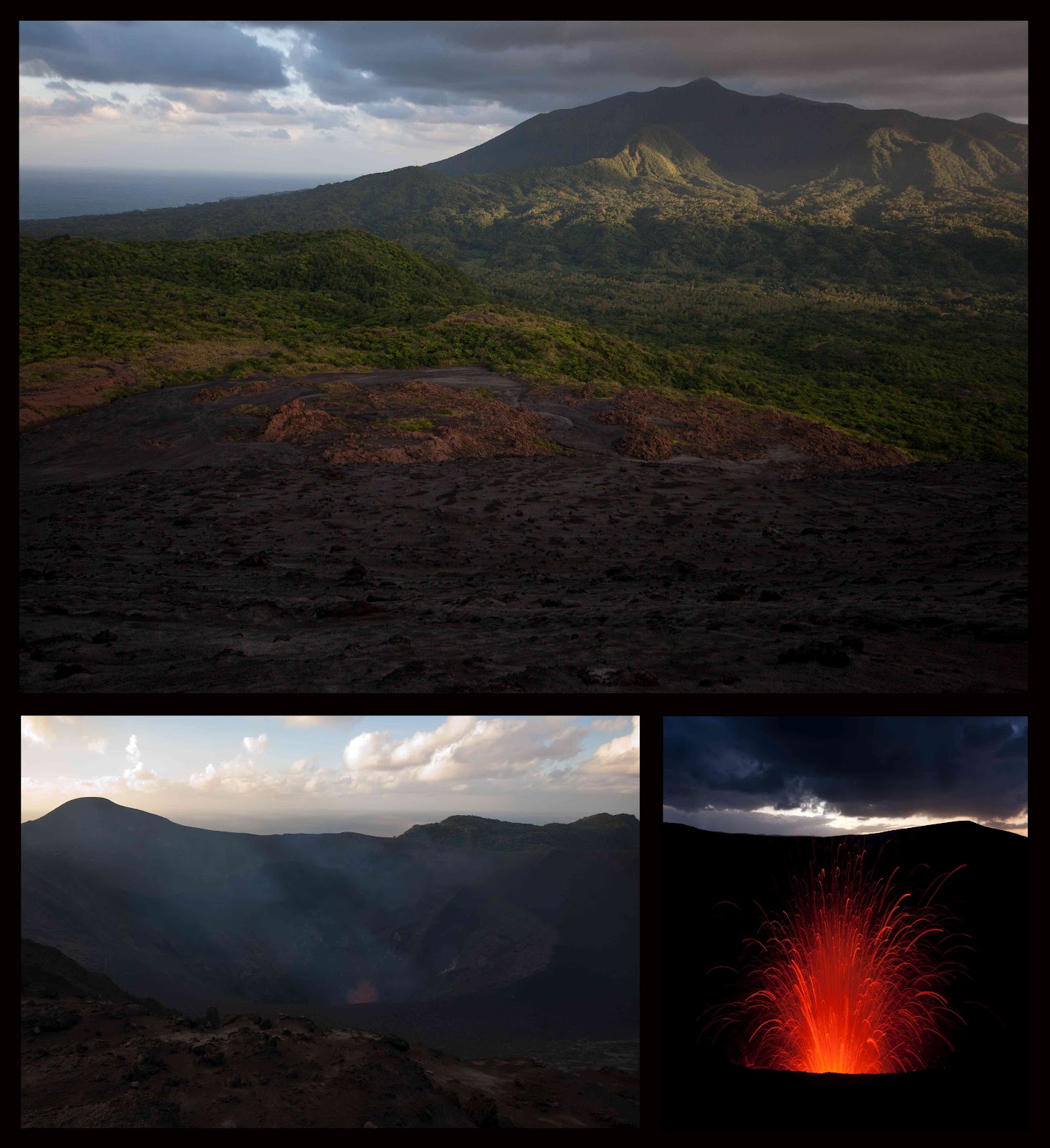 |
| Mount Yasur |
About an hour after sunset, we headed back down to the truck
with our flashlights and woke up our driver.
It was another bumpy ride back to the boat with a beautiful full moon
overhead. Our plan was to stay for only two
nights to see the volcano and walk around the island a little. The wind was forecast to shift to the east,
which meant that the swell would enter the anchorage in the following days, and
we wanted to leave before it got too rolly.
We left while it was still blowing from the SE, giving us a
nice downwind run north to Efate. We
covered the 140 miles north to Port Vila in about 23 hours, and picked up a
mooring ball, tucked between the waterfront and the small Iririki Island. Efate is the most populous island in Vanuatu (approx.
50,000 people) and the third largest. Most
inhabitants live in Port Vila, which is the national capital.
We found the city to be a bit too touristy and crowded, but
they had modern conveniences like wifi, grocery stores and fresh water, which we
were excited to see. We were especially
looking forward to doing some shopping for fresh food, and frequented the
central market where people were selling fruits and vegetables. Most of the vendors were women from the outer
villages that would come in with their produce and stay for a week at a
time. Many of them slept on the floor
under their tables. You could stop by
anytime, day or night, and buy some produce.
We stocked up on pineapples, huge avocados, papayas, bananas, and
eggplant.
There were also small food stands where women would cook,
and they usually had a table and a few chairs outside. You could buy a huge plate of food with rice,
vegetables and fish or beef with curry for 400 vatu ($4 USD). We ate several meals here, and they were quite
good. |
| Port Vila market |
On our way into the bay, we were happy to see our friend
Kevin on Tuatara in the anchorage. He
was there with his new crewmember, Joan, a backpacker from Spain that he picked
up in New Zealand. We hung out with them
a bit while we were in Port Vila and even spent one evening visiting a nakamal,
local kava house.

After about a week, we decided it was probably time to be
moving on, but we checked the weather and it looked like a low pressure system
was going to move through in a few days.
This meant that high winds from the west (trade winds usually blow from
the southeast) would be coming. We
didn’t want to sail against the strong winds, so we decided to hang out for
another week. Unfortunately, it also
meant the swell would be entering the usually protected harbor in Port Vila.
As predicted, the westerly wind blew hard for a few days and
large swells did enter harbor. We were
tucked up behind the small island of Iririki, so we didn’t get any of the big
waves, but it was rolly for a few days. It was also difficult getting to shore in our
little dinghy, and we were usually pretty wet by the time we tied up. The local boats that were usually moored
along the waterfront moved out to the moorings as well, and it got a bit
crowded out there. It was a good thing they did though, as the swell was
breaking on the waterfront wall near the market, dousing the normally dry
walkway and vendor stalls.  |
| big waves in Port Vila |
We kept busy preparing Saviah for our next passage, stocked
up on provisions, and checked out with customs and immigration. It also gave us a chance to take care of some
final paperwork we needed to do in advance for Bali. After a few days of westerly winds, it turned
around again, and we needed to get going.
We only spent three weeks in Vanuatu and didn’t see any of the northern
islands at all, but we have a lot of distance to cover this year. So, we left on June 16th and headed northwest
toward the Torres Strait.